See This Project | Similar Projects | All Projects for Client
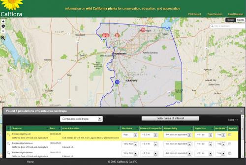
The California Invasive Plant Council (Cal-IPC) asked GreenInfo to develop WHIPPET (Weed Heuristics: Invasive Population Prioritization for Eradication Tool) which helps land managers prioritize which invasive plant populations are the most effective to control, based on the invasive plant species, population locations, and population characteristics.
Given a set of point locations where invasive species have been noted ("populations"), WHIPPET scores each population in three categories: Impact, Invasiveness, and Feasibility of Eradication. Each category contains weighted criteria and subcriteria which are them summarized into a final score for the population, indicating the priority of removing or limiting the growth of that population.
WHIPPET was initially designed as a master’s project at the University of California at Davis with consultation and data from the California Department of Food and Agriculture’s Noxious Weed Program. The original version ran as a series of Excel spreadsheets. In 2013, TerraGIS and GreenInfo Network were awarded a contract by the Cal-IPC to rewrite it using a web mapping interface, loading plant location data from web services at Calflora.
Access to WHIPPET is available by signing up for an account at Calflora.
Results: The complex set of spreadsheets previously used to analyze plant populations, has been turned into an easy-to-use web tool. As a result, personnel at Cal-IPC are able to use it more easily and more quickly, and therefore more often. As a result, they make better-informed decisions about which invasive populations are most feasible and valuable for control or eradication.
Focus: Conservation, Environment
Services: Interactive Solutions, Applications Development, Web Mapping, Website Design
Tags: modeling, OpenLayers, weeds
Project Years: 2013-2014