See This Project | Similar Projects | All Projects for Client
The nature of the forests of the eastern U.S. and the threats and opportunities facing them were the key subjects in a GreenInfo project. that began as a simple map and ended up being a multi-faceted strategic communications initiative.
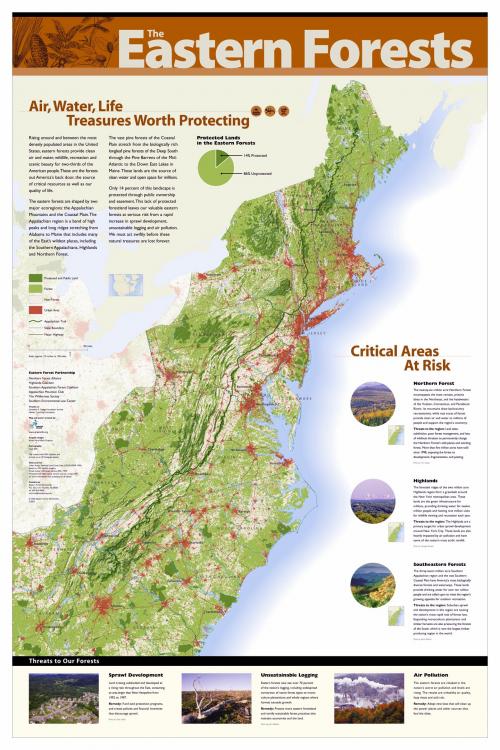
The Eastern Forest Partnership (EFP) was a project of the Appalachian Mountain Club and other pro-forest organizations seeking to educate Congress and the public generally about the nature of issues facing the forests of the eastern seaboard. The partnership came to GreenInfo Network to help them develop map-based materials to support their outreach. As the project developed, the effort to develop a map poster transformed into a much broader strategic planning and communications initiative. GreenInfo Network was originally asked prepare maps showing many layers of data about forests in the east. Using GreenInfo's normal approach to such projects, we prepared some basic maps but quickly focused the EFP on the question of who they were attempting to persuade and the nature of their most important messages. This led into exploratory mapping to more carefully define "eastern forest" - from a core of land along the Appalachians, the project evolved eventually to the entire east coast, from northern Florida to the tip of Maine and to the extent of forest areas west. This made for a more compelling story.
GreenInfo also developed concepts for what the EFP "story" should be - how the flow should go of their arguments about the forest and policies for its protection. The main vehicle for this messaging was a graphical poster with a map at its core. The poster defined a sequence of big messages and gave the organization a much improved graphic identity. Working with GreenInfo staff on this was designer Karen Parry of Black Graphics.
The final poster was 36"x54" and was frequently used at events and in meetings with Congressional staff (a smaller size was used for these meetings). A supplemental brochure and a branded website were later developed by Black Graphics. This project is an excellent demonstration of GreenInfo's capacity to link GIS data research and analysis to communications messaging and strategic planning.
Results: The Eastern Forest Poster created by GreenInfo and its design partner was actively used for many years of a campaign to secure improved protections for the forests of the east coast.
Focus: Conservation, Environment
Services: GIS Services, Communications, Graphic Design, Strategy, Maps, Cartography
Tags: Appalachian Mountains, Eastern Forest, Esri ArcGIS, forests, Illustration, infographic
Project Years: 2001-2011