See This Project | Similar Projects | All Projects for Client
When one of our staff members moved to St. Paul, she wanted to quickly find parks and activities nearby to which she could bring her young daughter - but there were only park lists and a printed recreation catalog document. Wondering how many other families were facing the same needs, she began framing the idea of an application that could help cities respond. At the same time, she learned that the Knight Foundation had a special grant program, which ended up funding GreenInfo to develop a full prototype application, now the Get Outside Toolkit.
When we first heard about the Knight Foundation's News Challenge on Open Government, we were both excited and somewhat daunted in submitting a proposal. In all, over 800 technologists submitted ideas to address the challenge: "How might we improve the way citizens and governments interact?" In our proposal, we considered the question "How might cities improve access to parks and recreation opportunities?" We sketched out ideas for a modern application that park agencies could adopt to provide a "What's Nearby" map. We were pleased to discover that our proposal was one of handful of projects chosen for The Knight Foundation's newly established Prototype Fund. We received a grant to prototype a mobile parks and recreation application template that could help thousands of public agencies.
The prototype grant kicked off with a Human Centered Design workshop where we learned new techniques for determining user needs, brainstorming innovative approaches, designing and testing and refining paper prototypes.. As we started into the design process, we realized that we were actually tackling two projects:
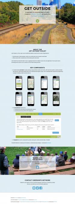
1) Design a core web application to help citizens quickly find parks and recreation opportunities – the end user framework of our project, usable on phone or desktop.
2) Design an administration tool to make it easy for cities to publish their data to this parks and recreation finder, which would self-configure so they wouldn’t need to develop their own application, once they aligned their data feeds.
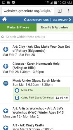
We worked closely with users from two pilot cities to determine design requirements for the parks and recreation finder. Through a community design and voting process, we found that users are most interested in mobile maps, though we learned that residents also highly value printed maps and events handouts, email and text message reminders. As a result of our work with local users, we determined that the ideal parks and recreation finder would be a flexible tool that could reach users in a variety of ways (mobile application, printed/translated materials, text message subscriptions, etc.).
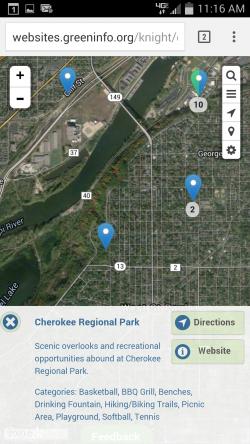
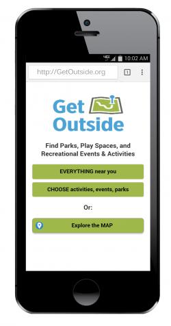
This led us in the direction of creating a toolkit that cities could use to share parks and recreation information in a variety of formats (mobile, SMS, print, etc.). We called this the “Get Outside Toolkit”. Within the limits of this prototype grant, we focused on creating one application format, mobile web, as this would allow for reasonable desktop use, but be easily adaptable to the key user device, a smartphone. We created paper design mockups and engaged users in several rounds of think aloud testing in order to come up with a robust design for a mobile parks and recreation finder. We developed a wide range of designed screens to support this process.
Simultaneously, we conducted contextual interviews with three cities to learn more about their internal processes for maintaining parks and recreation data. We learned that most cities have limited staff resources to dedicate to maintaining a parks and recreation application. They often use Google Calendar and Google Docs to list the addresses of recreation centers, and to share information about their open hours and upcoming events, and are hesitant to update this information in a second location. When geospatial information was available, such as the locations of parks and rec centers, it was available as an ArcGIS service or a Google Docs spreadsheet, requiring additional expertise and resources to adapt it into a web map. Because of this, we determined that the tool should integrate with agencies’ existing data sources that they already actively maintain.
And it does. A series of "drivers" was developed, to read data from a variety of location sources (Google Docs spreadsheets, ArcGIS, CartoDB, WFS) and a variety of calendar sources (Google Calendar, Active.com, and RSS/iCal feeds from websites). The "fetch and update" process integrates them into the same database, so the existing data maintenance processes will "just work" on the mobile-friendly parks website generated by Get Outside Toolkit.
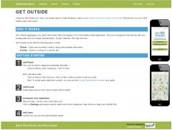
In working with the City of St. Paul Parks Department, we succeeded in developing a prototype that actually is a fully functional product. Any city can download the Get Outside toolkit from Github and launch a mobile parks and recreation finder in one day! Simply edit a few configuration files to specify URL and database connection details, upload to a web server, and add parks and events data sources (either from a Google spreadsheet, iCalendar feed, GIS database). The Get Outside Toolkit is designed to use standard PHP extensions and the MySQL database server, so it may be deployed on common, low-cost web hosting services.
While the GetOutside toolkit is published on Github and available for use, this is a beta version. GreenInfo is now developing a next set of tests and looking for investment to make this available to over 20,000 park and rec agencies. Contact us if you can help!
For more details on this project, read the Knight Foundation story on Get Outside Toolkit »
Results: The Get Outside application was implemented for the City of Saint Paul and the open source code is available on the project web site for anyone to download and use. GreenInfo continues development of this application.
Focus: Environment, Government Agencies, Recreation
Services: Interactive Solutions, Applications Development, Web Mapping, Mobile Applications
Tags: mobile, open source, parks, recreation
Project Years: 2014-2015