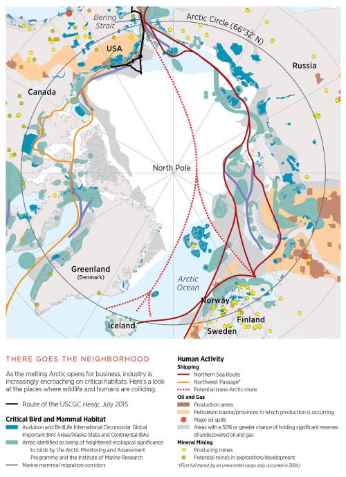
Audubon approached us in November 2015 with a page of space in their flagship magazine and an array of critically important data about how the Arctic is changing. Tim Sinnott worked with magazine staff to turn that data into a clear story of how climate change impacts and expanding industry in the north increasingly overlap with crucial wildlife habitats.
We started with a couple of reference maps to inform our map's boundaries and projection, as well as a basic layout with font suggestions and a handful of recommended colors. Audubon staff provided us with a variety of data sources, including shapefiles, CSVs for point locations, and PDF maps that would need to be digitized. After preparing all of the data and gathering the layers in one place, we initially compiled two maps, one focused on habitat, and one focused on human activity. Although the list of data layers was growing, there was a story emerging in the overlaps of the two categories of data.
After viewing both maps side-by-side, our partners at Audubon wanted to see how it would look if we created one map that combined all the layers, so we set out finding the best way to display the growing list of data sets. We made the decision to push all human activity layers to warm colors and habitat layers to cool colors. We combined a couple of layers into one subcategory and removed some layers that were visually confusing. And lastly, layers that were of greater impact or importance, or layers that were getting lost in the mix, were made brighter or more saturated. Background layers were more muted or toned down. The resulting map is the product of true collaboration. We had the opportunity to work with great partners with a clear vision at Audubon, and in a few short weeks, create a map that was not only legible, but told an important story.
Focus: Environment
Services: GIS Services, Communications, Graphic Design, Publications, Maps
Tags: Arctic,
Audubon,
Esri ArcGIS
Project Years: 2016