Similar Projects | All Projects for Client
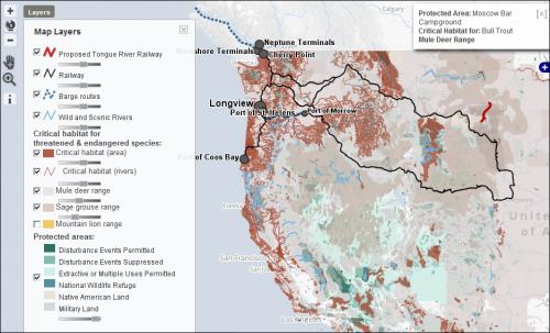
The National Wildlife Federation sought to illustrate the interaction between expanded coal operations and sensitive environments in the Northwest US. GreenInfo built an interactive map which allows users to see the geographic interaction of these factors.
In "The True Cost of Coal" NWF reports:
Faced with stagnant demand for coal in the U.S., some of the world's largest coal companies want to ship millions of tons of dirty coal per year through the Pacific Northwest to China and other Asian nations looking to feed their rapidly growing energy appetite.
The uncovered, coal-laden rail cars would run through sensitive ecological areas (like the Columbia River Gorge and Glacier National Park) to six proposed terminals in Oregon and Washington. Increased train and tanker traffic, air and water pollution from diesel and coal dust, carbon pollution that fuels climate change, and disturbance of wildlife habitat combine to make these proposals some of the most environmentally threatening projects in the country.
Focus: Conservation, Environment
Services: Interactive Solutions, GIS Services, Cartography, Web Mapping
Tags: Coal, environment, Northwest United States, OpenLayers, Oregon, Washington
Project Years: 2013