Similar Projects | All Projects for Client
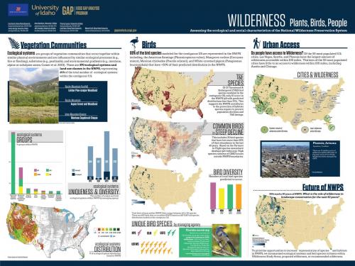
Conference posters done by researchers are often very information-rich and not visually engaging. GreenInfo was asked to develop a very different approach for a poster depicting a public agency's research on wilderness areas in the United States.
Our approach was start by distilling large amounts of data, charts and writing and develop an overall messaging framework. We then used a mockup design to determine how visual elements might relate and just how much space we had for all the desired information. It quickly became apparent that we needed to greatly limit the researchers' total information resources, in order to allow viewers to quickly digest a coherent message.
We used GIS to develop map elements and illustration software for charts and overall layout for the 30"x24" poster. After several rounds of review by the researchers, we printed posters for them and also produced 11"x17" handouts for them to use at the conference.
For GreenInfo, this project is a great demonstration of what we do best - take complex geographical information and find creative ways to making it accessible and compelling to those who will see it.
Focus: Conservation, Government Agencies
Services: GIS Services, Communications, Graphic Design, Presentations, Strategy, Maps, Cartography
Tags: Esri ArcGIS, Wilderness, Wilderness Act
“ We are very pleased - you did an excellent job communicating our story and we are excited to tell it. They layout is great and we appreciate your cues for more evocative information.”
— Lisa Duarte, USGS PAD-US National Coordinator
Project Years: 2014