The Peninsula Open Space Trust is one of the largest and most effective land trusts in the United States. Known as POST, it focuses on the areas west of Silicon Valley in the San Mateo and Santa Clara county areas of the Bay region. During a major revision of its web site, POST's design consultant asked GreenInfo to assist by building a web map that would showcase the many successful land conservation projects that POST has undertaken.
In this case, the the web designers had developed an approach to the property finder, including iconography, page layout, mobile responsiveness, and workflow. The page functioned as a living mockup of the layout and workflow, but it was up to GreenInfo to implement the actual mapping, loading of the geographic markers, and searching and filtering functionality to rendering into these layouts.
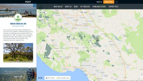
The first step was to collect the POST holdings as both areas to be displayed on the map, as well as a set of geographic markers based on those areas. A Python program and accompanying documentation was written for the consultants to use when they had the geodata ready, and which would generate both of these datasets in the KML format ready for web publication.
The second step was programming the page from a workflow mockup to an actual mapping application. The placeholder Google Maps screenshot was replaced with a real Google Maps map, and POST's markers and areas were plotted onto it from those web-ready files generated previously. At this point, the mockup had become a basic map with the user able to click on markers and areas to see information about the areas. During this process, specifications changed several times as usability considerations and improvements were found. GreenInfo responded quickly to these changes, both accommodating client requests as-given and suggesting modifications based on past experience with maps and client usability.
Lastly, the search interface was brought into operation. Selecting a land-use type examines the markers to find POST holdings which matched that same land-use type, and the resulting list would be dynamically inserted into the scrolling interface for the user to peruse. During this process, the search interface underwent some modifications due to "real world" data differing from the original expectations. For example, some very-long holding names did not fit into the area adjacent to the markers, and holdings could have multiple land-use types instead of only one. Again, GreenInfo both generated bullet-list items for consideration and feedback, as well as responding to client-generated requests, improvements, and issues.
This whole process was accomplished over a very short timeline, with the consultant having contacted us only two weeks before the scheduled soft launch. GreenInfo achieved basic functionality ahead of the scheduled soft-launch, followed by multiple rounds of feedback and improvement in time for the final launch four weeks later.