See This Project | Similar Projects | All Projects for Client
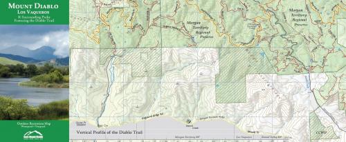
A giant-sized map of Mount Diablo State Park, Los Vaqueros & the surrounding open spaces is an incredible resource for hikers and other park users - this is an updated edition.
Working with Save Mount Diablo's local experts and generous volunteers, GreenInfo made this authoritative map even larger and more accurate. The map includes trail distances and elevation markers for trail junctions, as well as an elevation profile of the 30-mile Diablo Trail. Save Mount Diablo is so prolific in their work protecting essential areas of the east bay area that it's difficult for cartographers to keep up-to-date! This project was a unique partnership that had GIS contributions and feedback between GreenInfo and SMD volunteers. You can pick up a copy of this waterproof and tearproof map from Save Mount Diablo or from local stores such as REI.
Focus: Conservation, Environment
Services: GIS Services, Communications, Graphic Design, Publications, Maps, Cartography
Tags: Adobe Illustrator, Esri ArcGIS, parks, trails
Project Years: 2012