Similar Projects | All Projects for Client
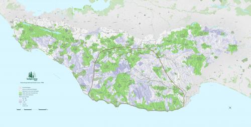
Sempervirens Fund came to GreenInfo with the request to create a large display map for their new office, covering a 10'x10' wall area.
Using its CPAD protected areas data and other information, GreenInfo created map 6 by 11 feet, which showed the land trust's focal region and the surrounding public and unprotected private parcels. The map is used for board and staff strategy meetings and as a general illustration for visitors to Sempervirens' office.
This project originally started as a large "tiled" map - where individual small sections are printed then mounted together - but evolved into one large printed map. Because of the large size of the map, it took GreenInfo staff time to get the labels just right, in terms of size and placement - a map looks very different on a computer monitor compared to being printed at 6' by 11'!
Focus: Conservation
Services: GIS Services, Maps
Tags: conserved lands, Esri ArcGIS, Redwoods, San Francisco Bay Area
Project Years: 2010-2011