See This Project | Similar Projects | All Projects for Client
The Martis Valley just north of California's Lake Tahoe is a spectacular setting. In the early 2000s massive development proposals were offered by landowners that would overtax the area's services and damage its environment. Sierra Watch was created to respond to this threat and engaged GreenInfo to help with campaign mapping projects
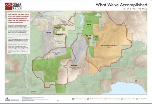
Home to a major ski area (Northstar) and bordered by the Town of Truckee, the Martis Valley contains thousands of acres of valley and forested hills, along with a significant amount of existing homes and businesses. With a County General Plan calling for up to 30,000 new residents in the Valley, Sierra Watch raised alarms about the impossibility of servicing that growth and its consequences for the environment. After a long campaign and legal actions, an agreement was reached that limited development and provided major funding for conservation and restoration work in the Martis Valley.
One key part of this effort was Sierra Watch's diligence in developing, through GreenInfo Network, clear, persuasive maps that showed issues and opportunities in the Martis Valley. When the organization successfully completed its campaign, it also commissioned an accomplishments map from GreenInfo Network, which continues to be used in the next phases of its efforts. In addition to supporting the Martis Valley campaign, GreenInfo's map won 1st prize in the 2011 Esri International Conservation Mapping Contest.
The key to the map was a combination of clear message and outstanding GIS-based cartographic technique. It tells a "layered" story at each viewing distance, presenting just the essential information at each of those points.
Results: The Martis Campaign has resulted in millions of dollars for conservation and habitat restoration.
Focus: Conservation
Services: GIS Services, Maps
Tags: California, Esri ArcGIS, Martis Valley, Sierra Nevada
“ GreenInfo Network’s Martis Accomplishments map achieves something many maps can’t: it tells a story and pushes the narrative. It not only depicts our ongoing success in turning development threats into conservation opportunities in Tahoe’s Martis Valley, it helps people understand what we still seek to accomplish.”
— Tom Mooers, Executive Director, Sierra Watch
Project Years: 2009-2013