Similar Projects | All Projects for Client
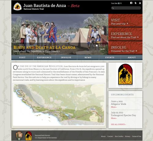
In 1775, Juan Bautista de Anza led a 200 person expedition 1200 miles, from the Mexican border to San Francisco, California, establishing settlements along the way. The National Park Service unit that manages this trail corridor worked with GreenInfo to develop a three part plan for improving public information about the trail: a new web site, improved maps and geographic data, and an interactive tool for identifying recreational trails.
Building this website began with extensive background research into existing resources and working with the National Park Service (NPS) staff to define vision, audiences and purpose. GreenInfo staff led a design process that clarified the site's purpose and functions, then created wireframe designs to transfer that information into a web site concept.
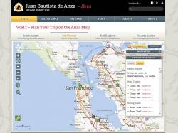
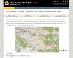
GreenInfo staff then researched and centralized large amounts of existing public information on the expedition, into a series of databases. This included text descriptions, diary entries, photos/graphics and much more. The mapping element of this project provided an extensive library of county and regional maps for the site.
At the same time, other GreenInfo staff began developing the interactive map for the site, enabling it to be used by many different users - those researching the expedition, those looking for nearby trails and cultural opportunities, those planning visits to areas of the trail, and teachers and students learning about the historic expedition.
The next phase was working with our longstanding design partner, Ison Design, to create a graphic identify for the site and to refine how the visual layout, colors and fonts would all function together.
GreenInfo staff then programmed the site, creating a large database to drive its pages, and including a robust web mapping application.
The entire site came together in late 2012 and was refined until its beta launch in early 2013. Some areas of the site will be further developed in the near future.
Focus: Environment, Government Agencies, Recreation
Services: Interactive Solutions, Applications Development, Web Mapping, Website Design
Tags: Anza, Arizona, California, historic trail, National Park Service, NPS, trails
“ The website looks great and we hope it will be a great tool for connecting with the public, expanding the Anza Trail volunteer base, and growing the Anza Trail Foundation. Thanks for helping us refine our vision for what this could be, and for making it a reality!”
— Steve Ross, National Park Service, Anza Historic Trail
Project Years: 2011-2013