See This Project | Similar Projects | All Projects for Client
With over $300 million in bond funded grants available for providing and improving local parks, the California Dept. of Parks and Recreation was faced with the challenge of how to rank applicants for this funding - by law, the funding was mainly to help park-poor and lower income areas. They turned to GreenInfo to build an innovative web application.
Prior to 2010, when State Parks had funding to improve parks in needy areas, they had to evaluate applications by hand - testing applicants' claims of whether there were already parks nearby their projects and that they would serve lower income communities. There was no consistency and the process required extensive staff hours.
GreenInfo had worked with State Parks on developing the CPAD (California Protected Areas Database) inventory of parks and other fee-owned open space lands in the state. This GIS data set had most parks already identified, in a very accurate manner. GreenInfo staff proposed to State Parks Office of Grants and Local Services (OGALS) that they apply this data to their new grant funding round and build a web mapping application that could give all applicants a consistent process for their grant proposals.
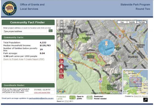
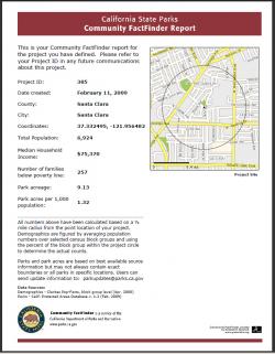
Community FactFinder was developed to do this job. A simple web interface enabed users to find a project site, place a virtual pushpin on the web map and quickly get a report of what was in the half mile (the state standard distance) around that site. The report displayed on screen and showed park acres per 1,000 residents and census-based demographics in that radius. The user saved this data under a unique ID, generated a well-formated PDF page report of the analysis and then submitted this to State Parks in its grant application. Only if certain FactFinder thresholds were met could the application be considered. FactFinder also had a back end where State Parks could review applications and test applicants directly.
Because so much funding was at stake, some applicants offered up information that might change their metrics. GreenInfo and State Parks staff worked closely on a process to evaluate this data, sometimes changing FactFinder data where special circumstances occurred and sometimes providing definitive explanations back to applicants as to why the FactFinder analysis was indeed valid.
Results: The use of GreenInfo's FactFinder application is estimated to have save the State Parks Department over $100,000, at a cost of under 20 percent of that figure. It also created a consistent application framework for hundreds of grantees, improving government efficiency and effectiveness.
Focus: Conservation, Environment, Government Agencies
Services: Interactive Solutions, Applications Development, Web Mapping
Tags: California, CPAD, FactFinder, parks
Project Years: 2009-2012