See This Project | Similar Projects | All Projects for Client
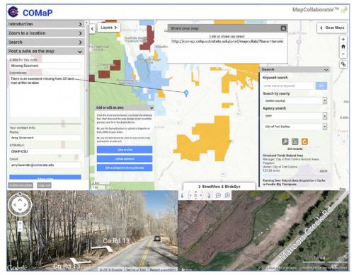
COMaP is the Colorado statewide GIS inventory of protected areas. Managed by Colorado State University (CSU), the data set is part of PAD-US and includes lands owned outright as well as conservation easements. As part of a program to upgrade the inventory, CSU asked GreenInfo to develop a MapCollaborator application that could aid in contributing and reviewing data from partner organizations.
When the entire COMaP system was released in mid-2016 (including the MapCollaborator application), it was announced as follows:
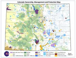
The Colorado Ownership, Management and Protection (COMaP) service provides the state’s premier map of protected lands. COMaP features over 28,000 entries of protected lands parcels from over 300 different data sources, each of which contains a suite of attributes such as owner, manager, easement holder, public access, and more. Since its inception in 2004 at Colorado State University, COMaP has become the go-to resource for land managers, land owners, and the conservation community.
Conserved lands are woven into the fabric of Colorado, making up nearly 35 percent of the state, or roughly 30 million acres, according to the Statewide Comprehensive Outdoor Recreation Plan. Even more acreage is conserved through conservation easements on private lands.
These lands are managed by a plethora of public agencies at every level of government as well as non-governmental organizations like the The Nature Conservancy, local land trusts and even private land owners. Can you imagine bringing all of them together to build a map of protected areas throughout the state?
The task is so daunting that there is, in fact, only one comprehensive map of Colorado's protected lands in the state, and in its 10th version, it's making a tremendous breakthrough. The Colorado Natural Heritage Program, with help from Colorado State University's Geospatial Centroid, recently launched a new COMaP system, for the first time allowing subscribers to use the map in a web-based interface.
COMaP, the Colorado Ownership, Management and Protection Dataset, started as a Geographic Information System research project in CSU's Department of Fish, Wildlife, and Conservation Biology in 2004. Since then, it has evolved into an important tool for those around the state with an interest in privately and publicly protected lands.
COMaP 10 changes everything. The web-based system is accessible to subscribers through web browsers, and if you can use Google Maps, you can use COMaP. The new version also allows users to submit edits and suggestions directly to CNHP staff, allowing them to vet and apply updates quickly and efficiently.
Focus: Conservation, Environment, Government Agencies
Services: Interactive Solutions, Applications Development
Tags: Colorado, mapcollaborator, parks, Protected Areas
Project Years: 2013-2016