Looking back a century at LA

Taylor Yard in 1897
Client:   UCLA Institute on the Environment and Sustainability

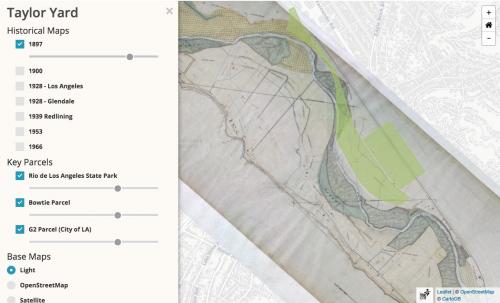
Frequent collaborator Jon Christensen, of UCLA's Laboratory for Environmental Narrative Strategies, asked us to develop a simple interactive map to let readers peel back more than a century of history at Taylor Yard, a crucial parcel along the Los Angeles River. The parcel is at the heart of an unfolding story about revitalization, gentrification, and urban nature.

The map we developed was part of a feature package developed in a collaboration between LENS, NPR-affiliate KCET, and the Atlantic's CityLab blog. 

Small projects like this come in and ship quickly, and we love doing them, especially when the results can help shape public discourse on important topics like urban habitat, gentrification, and access to nature within cities. 

Focus:   Economic Development, Environment, Recreation  

Services:  Interactive Solutions, GIS Services, Data, Web Mapping 

Project Years: 2018

GreenInfo Network creates, analyzes, visualizes and communicates information in the public interest. We specialize in mapping and related technology for nonprofits and public agencies, focusing on using it for conservation, social equity, public health, environment and foundation grant making.
2201 Broadway, Suite M5
Oakland
CA
94612
United States of America