Similar Projects | All Projects for Client
Over 1,500 land trusts operate in the United States, saving a wide range of natural resources by securing conservation easements and implementing stewardship plans. The national association of land trusts asked GreenInfo to illustrate the types of mapping that most trusts would find useful, placing these examples in a poster form.
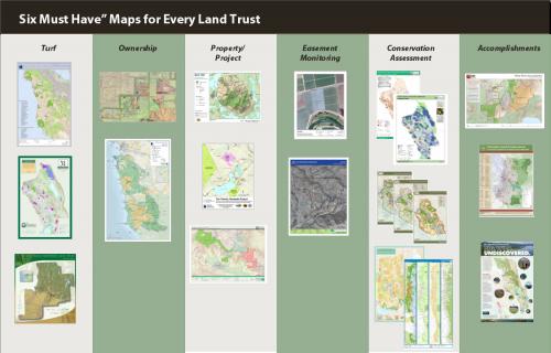
Most land trusts need a core group of six types of maps to support their conservation and stewardship missions. GreenInfo Network assembled this poster highlighting options for these types of maps and displayed it at the annual Rallies of The Land Trust Alliance. The six categories illustrated are:
- "Turf" maps, showing the area of operations of a land trust
- Ownership maps showing parcel patterns in a planning or project area
- Property maps, detailing the boundaries and features of individual holdings
- Maps that support easement monitoring, including photo points and more
- Conservation assessment maps that support strategic planning
- Accomplishment maps that aid in public and funder outreach
This 3x4' poster can also be ordered online at ImageKind.
Focus: Conservation
Services: GIS Services, Communications, Presentations, Maps
Tags: conservation planning, easements, Esri ArcGIS, land trust, stewardship
Project Years: 2010, 2012