See This Project | All Projects for Client
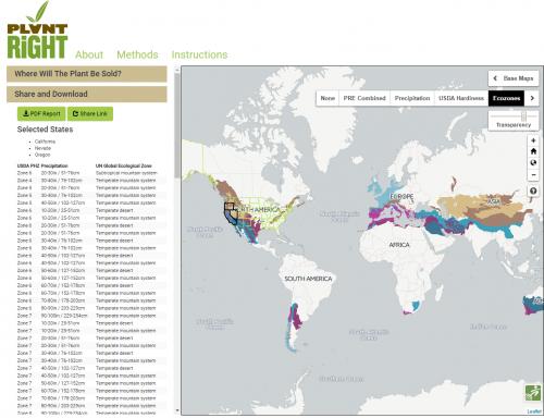
The climate match toolkit, is part of PlantRight's Plant Risk Evaluator (PRE). When the user selects an area from the list or from the map, the map is updated to highlight the areas with matching precipitation, ecozone, and plant hardiness zone. This update is done within the browser without calling to the web server, and response times are nearly instant.
PlantRight's Plant Risk Evaluator (PRE) is a collaboration between GreenInfo Network, PlantRight, Cal-IPC, and Agricultural Sustainability Institute at UC Davis. Funding is provided by Sustainable Conservation. Horticultural growers or plant scientists interested in promoting exclusively non-invasive plants for regional markets can join the PRE community.
GreenInfo designed and built the "climate matching tool" component of the PRE. A user selects one or more areas (States or Ecoregions, using a list or clicking the map) and the map instantly updates to highlight the areas that are similar to what the user selected. This process evaluates three factors: Precipitation, the USDA Plant Hardiness Zone, and the UN Global Ecozone. You can view each factor individually or see where all three conditions match. This update is done within the browser without calling to the web server, and response times are nearly instant. To save and share results, you can get a share link that will reload exactly the areas you or download a PDF report containing all four maps and the listing of matching criteria.
Based on the work we did here, we created an open source plugin so we and others can easily do similar filtering on categorized raster data.
Focus: Conservation, Environment
Services: Interactive Solutions, GIS Services, Analysis, Data, Web Mapping
“ So exciting, so speedy, and being able to see the individual layers is fabulous. WOW!”
— Jan Merryweather, Senior Project Manager, Sustainable Conservation
Project Years: 2016