
See This Project | Similar Projects | All Projects for Client
In order to qualify for federal Land & Water Conservation Fund grants, states have to develop State Comprehensive Outdoor Recreation Plans (SCORPs) every five years. The Georgia Department of Parks and Recreation wanted to ensure that its new SCORP took into account an actual inventory of recreational activities in all the parks in the state. Because of GreenInfo's experience in this work, they asked us to help them develop that inventory.
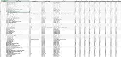
To begin this project, GreenInfo used two data sets for Georgia - a parks boundary data set that was prepared in 2012 by researchers at the Univ. of Georgia, Athens, and contributed to PAD-US, the national inventory of such lands, and a very detailed inventory of recreation in many parks in Georgia, also created by UGA researchers. There were two challenges in working with this information - the two data sets were not matched to each other, and the data in both was a number of years old. In addition, the recreational activities data (hiking, camping, swimming, etc.) was extremely detailed, with over 50 attributes noted - updating this much information was beyond the scope of available resources.
GreenInfo staff started by condensing the activity data down to a set of 13 core activities desired by the Parks Department. This mean crosswalking many detailed activities into overall activities, as well as dropping many activities that weren't widely used.
The activity data was tied to GIS points (not polygons), so the next challenge was to move this data from those points to the polygon data. We performed a number of "clean ups" on the polygon data, and then we conducted a spatial intersection of the points with the polygons - where a point fell in a polygon, its activities could be easily linked; where a polygon didn't exist, we needed to research the park and digitize if, if indeed it existed. We also found a great many extremely small "parks" which were really just landscape features (traffic circles, medians, etc.), and we had to develop rules to define and then set these aside as too small for recreational activities of interest to the state.
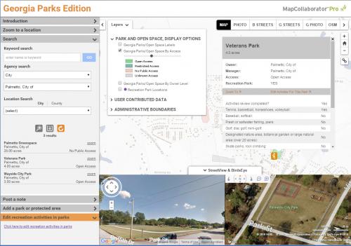
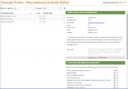
During all of this work, we had also developed an edition of our MapCollaborator tool, an indispensable web application to help review and annotate parks data online. In addition to the basic MapCollaborator functions of searching and making map notes, we also installed a recreational activities editor, which we had pioneered in another recent project. This editor allowed a user to pick a park and then access a full list of all possible activities, chose those that applied, add notes as needed and save the edits.
While GIS software is very valuable for many of these steps, the MapCollaborator application is far more efficient for researching data online, having many base map views, easy to use editing tools and a Street View/Birdseye view tool that lets users see very detailed images of what's in parks.
After researching many agencies (adding over 60), and parsing through the existing data to ensure it was current, we ended up with a very accurate database of 3.6 million acres, representing 4,600 parks, of which 2,700 had one or more recreational activity, totaling 2.6 million of the total acres. Half of these parks were larger than 10 acres.
Focus: Environment, Government Agencies, Recreation
Services: Interactive Solutions, GIS Services, Data, Applications Development
Tags: Esri ArcGIS, PAD-US, parks, recreation, SCORP
Project Years: 2016, 2020