See This Project | Similar Projects | All Projects for Client
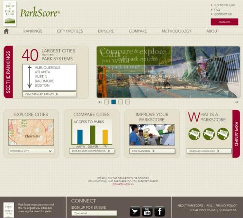
Trust for Public Land's ParkScore system is the most comprehensive rating system ever developed to measure how well the 40 largest U.S. cities are meeting the need for parks, in an effort to guide local park improvement efforts. TPL asked GreenInfo to help it design the structure of the site and its database and then implement the design and create the mapping functions.
Launched in 2012, the Trust for Public Land (TPL) ParkScore Project was initially a survey of 30 of the largest cities in the United States.
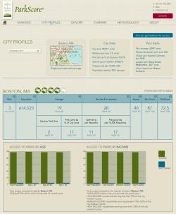
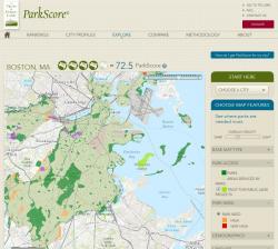
Using the criterion that a park's "service area" is a reasonable 10-minute walk (one half mile), TPL analyzed population density, park acreage, city spending on parks per 1,000 residents, and other factors to determine areas in which people effectively had no easy access to parks. These factors are quantified as a set of sub-scores and a final ParkScore rated 0 to 100.
The TPL ParkScore Project website presents the results in an intuitive and easy-to-read layout. Cities can be selected and browsed both as a map and as a set of detailed statistics, and cities may be selected and a side-by-side comparison generated. GreenInfo Network managed the technical design and development of the web site, while TPL managed the data and the ArcGIS servers which provide the data to the website.
Of technical interest is the mapping system. GreenInfo Network designed the front-end in jQuery and ArcGIS JavaScript API, while TPL manages the ArcGIS data services. All data presented on the site are dynamically loaded from the ArcGIS services, from the list of cities to the per-city statistics and map configuration. As a result, TPL can make updates to the ParkScore data and the changes are instantly visible on the public website.
Results: The TPL ParkScore website has been very successful - a 2013 update generated over 50 major TV and other news stories in less than a week. Even cities with lower scores are taking note, using the information to determine what they can do to improve their park accessibility. Plans are in place for a partner site, by which cities can submit scenarios for new parks and see how it affects their ParkScore.
Focus: Conservation, Environment, Public Health
Services: Interactive Solutions, Applications Development, Web Mapping, Website Design
Tags: ArcGIS JavaScript API, Google Charts API, park access, park equity, parks, ParkScore, TPL
“ Thanks again for another incredibly successful release of ParkScore! Check out some of the stories below...we also got a ton of TV and radio coverage. Very impressive. You guys rock!”
— Breece Robertson, National GIS Manger, TPL
Project Years: 2011-2013