See This Project | Similar Projects | All Projects for Client
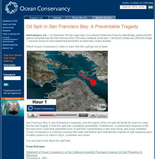
When an oil tanker struck a bridge in San Francisco Bay in 2007, the oil spill that resulted was nearly catastrophic, requiring months of clean up. But it didn't need to have happened this way. The Ocean Conservancy asked GreenInfo to help it create a video of why, all done within 30 hours of the spill.
Using printed maps of a model of oil dispersal over the course of one day, we scanned images, used GIMP to extract the oil extents from each of the maps, then saved as a series of PNG files with transparent backgrounds, preparing them for use in Google Earth. Within Google Earth, we georeferenced each of the PNG files using common landmarks in the scanned images and in the aerial imagery within Google Earth. We then exported a video using the Movie Maker function available in Google Earth Pro, transitioning between the oil dispersal maps, informed by breaks in the narration. A final edit was done using Windows Movie Maker, and the resulting video was uploaded to YouTube.
Focus: Environment
Services: Interactive Solutions, GIS Services, Communications, Presentations, Data, Web Mapping
Tags: Cosco Busan, Google Earth, oil spill, San Francisco Bay, YouTube
“ Thank you for pulling this together. It is GREAT. This will do more to electrify legislators to act than anything else we could do. Thank you, thank you, thank you!”
— Warner Chabot, Vice President, Campaign Strategies, Ocean Conservancy
Project Years: 2007