Similar Projects | All Projects for Client
Over a million acres of open space have been acquired in the Bay Area - until recently it was hard to tell the story of how these lands were acquired over the past decades. Our long time partner, the Bay Area Open Space Council, asked GreenInfo to build a tool and conduct research for defining those dates for lands in the Bay region.
GreenInfo, with the Open Space Council, has maintained protected areas data for California for a number of years (learn more about CPAD data >> ), but this data has not had acquisition dates as part of its attributes. Maria Santos, a researcher now associated with Stanford University, has worked on creating historical landscapes for some time - trying to use various data sets to portray how landscapes have altered over time and how the acquisition of parks and preserves have affected and been affected by events and trends.
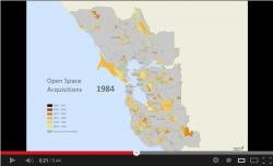
Here's a time animation video of the acquisition dates for the Bay Area.
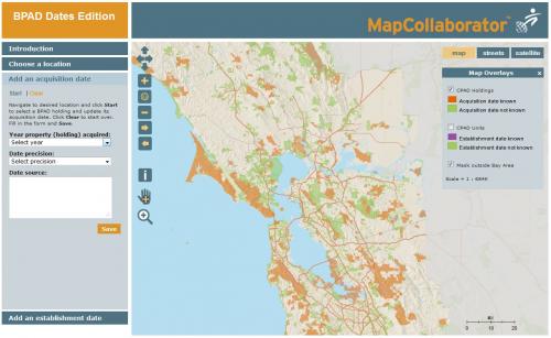
This project brought this group together around applying what Maria had discovered in research about dates and adapting the CPAD data set to account for it, and in developing a web application using GreenInfo's MapCollaborator technology, to aid in both defining acquisition dates and in reviewing data on dates. The task of determining when parcels were acquired is actually quite difficult and this first effort took many hours to track down dates and locations of purchases - as it turns out, many agencies' records of past acquisitions are not closely related to GIS data, particularly for older, pre-GIS era purchases. The combination of Maria and her students' research, GreenInfo staff efforts and some outside review through MapCollaborator made good progress, but more work remains.
Maria is now working on extending this effort to other parts of California.
Results: The first round of dates have been entered and the project is slowly expanding statewide.
Focus: Conservation
Services: Interactive Solutions, GIS Services, Data, Web Mapping
Tags: BPAD, California, CPAD, crowdsourcing, open space, parks
Project Years: 2012-2013