Similar Projects | All Projects for Client
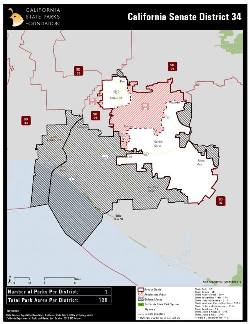
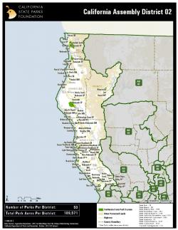
Advocating the interests of California's 280 state parks means a lot of time educating state legislators about the parks in their districts and the opportunities they have to improve and protect those parks. The California State Parks Foundation asked GreenInfo to create an atlas showing quickly the parks in each legislator's district and key statistics.
We started with a simple analysis using the most current California Department of Parks and Recreation data and intersecting with it with legislative district boundaries, to get statistical summaries for each district. The State Senate data was a bit more challenging to show visually due to the unique issue caused by the redistricting in 2012 -the unique circumstance of only the odd numbered districts going into effect in 2012 caused some areas of overlap and areas without coverage.
We designed the atlas using Esri ArcMap data-driven pages, using a simple design that fit with the Foundation's branding, and then quickly produced one page for each of 40 Senate Districts and 80 Assembly Districts.
This atlas is updated approximately every 2 years.
Results: GreenInfo created bound map books for the State Parks Foundation to bring with them to events and meetings with state legislators, a great tool to have on hand to visually show them how many parks they have (or don't have) in their district.
Focus: Conservation, Environment
Services: GIS Services, Analysis, Maps
Tags: atlas, California, Esri ArcGIS, legislative districts
“ The maps were widely successful. We created a packet of info that we drop off at the legislator’s office and the maps were included. A lot of the participants at Park Advocacy Day have started to request copies of the district maps that are relevant to their area. So, all in all, they are hit. Thank you for all your hard work on this project!”
— Kate Litzky, Research and Policy Assistant
Project Years: 2012-2017