Advancing 30x30 in the Bay Area

overall project summary
Client:   TOGETHER Bay Area

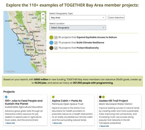
Our longtime partners at TOGETHER Bay Area had been deeply engaged in California's 30x30 initiative to conserve 30% of the state's land and water by 2030, and they needed a way to advocate for critical Bay Area conservation, equitable access, and climate resilience projects even before we know the exact details of how the statewide program works. Using the 30x30 highest level goals — biodiversity protection, equitable access, and climate resilience —they worked with us to develop a survey of their members that we rapidly turned into a visual, shareable landing page that highlights the work not just at a regional level but also for legislative districts, counties, and Native territories. The work was covered in the San Francisco Chronicle on April 19, 2022.

We knew that time was of the essence, so we wanted to build as little new complexity as possible. We developed a survey in SurveyMonkey (now Momentive) where we could quickly and easily assemble a survey for TOGETHER Bay Area's member organizations to submit up to five projects each to highlight on the final landing page. We wanted to make the data spatially explicit enough to tell a lawmaker what these projects would do for their district, without requiring project submissions to include complex geodata files. We built a place finder application that solved just that problem, locating a point within all the geographies needed for the application, which survey respondents could enter into the survey.

We were thrilled with the response -- we didn't know if we'd get 10 projects, and we got more than 100. We designed the presentation of the results to fit seamlessly inside TOGETHER Bay Area's website, to clearly present big numbers about dollars needed and jobs created and people served, and to be easily shareable, including with direct links for specific areas. So if an Assemblymember wondered how 30x30 could be advanced in their district, we can just send them a link.

Results: TOGETHER Bay Area used the tool and data to get coverage on the front page of the San Francisco Chronicle and to advance its case in Sacramento.

Focus:   Conservation, Economic Development  

Services:  Interactive Solutions, Applications Development, Web Mapping, Website Design 

Project Years: 2022

GreenInfo Network creates, analyzes, visualizes and communicates information in the public interest. We specialize in mapping and related technology for nonprofits and public agencies, focusing on using it for conservation, social equity, public health, environment and foundation grant making.
2201 Broadway, Suite M5
Oakland
CA
94612
United States of America