Similar Projects | All Projects for Client
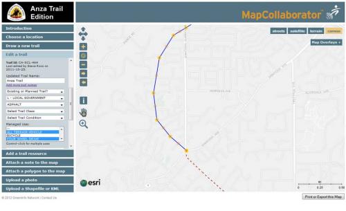
More than just celebrating the 1,200 mile Anza Trail, the National Park Service seeks to provide related hiking and recreational opportunities along this famous corridor. GreenInfo was asked to adapt its MapCollaborator tool to assist with defining and tracking these trails.
This edition of MapCollaborator is a very ambitious use of GreenInfo's "map wiki/crowdsourcing" technology. MapCollaborator's structured approach to choosing and adding/editing data makes it easy for non-technical users to quickly develop geospatial databases.
In this version, MapCollaborator has a very extensive database of trail and other attributes that users attach to geographic elements (lines, notes) they create. The National Park Service then has an administrative "back end" which allows their staff to edit and validate proposed trail additions or other contributions.
Contact GreenInfo to learn more about how MapCollaborator can help you with creating or reviewing GIS data.
Focus: Environment, Government Agencies
Services: Interactive Solutions, GIS Services, Data, Applications Development, Web Mapping
Tags: Anza, crowdsourcing, mapcollaborator, National Park Service, NPS, trails
Project Years: 2011-2013