Bay Area Greenprint Application

Client:   The Nature Conservancy - California

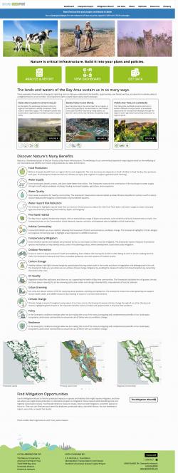
The value of ecological functions is often missed in public decision making about land uses — the role played by water recharge, habitat, climate resiliency and many other elements is limited in decisions about urban development, roads and other actions. The Nature Conservancy (TNC) has long championed the importance of these "nature's benefits" or ecosystem services and, with other leading Bay Area nonprofits, has worked with GreenInfo to design, build, maintain, and expand a major web application to turn science and policy thinking into an accessible tool for public agencies, advocates, or just about anyone concerned with the environmental implications of public decisions.

GreenInfo began work on the Greenprint project when TNC California, TOGETHER Bay Area, Greenbelt Alliance, and the American Farmland Trust California office asked us to prepare a review of "toolkit" options and strategies for their goal of stronger consideration of conservation in land use decisions in the Bay Area. This reconnaissance then transitioned into multi-year collaboration to develop the tool and its supporting information and then expand and adapt the work to more and more audiences and applications. Supported by the S. D. Bechtel, Jr. Foundation, the project was groundbreaking in its focus on detailed ecosystem services information for a large metropolitan region.

Since the original development in 2017, we have overhauled the application's design, added new features around nature in urban areas, and most recently added new report sections about resilience (climate, ecological, and community resilience) and California's 30x30 campaign. The data and tool have been used extensively by the Metropolitan Transportation Commission and many other local and regional partners.

TNC and the other project partners have taken on the considerable science assessment and analysis, bringing sophisticated and complex techniques to identifying and prioritizing ecosystem services for the web tool. Advisory groups on science and methods and on policy were convened and reviews of approach conducted. Over 100 data sets were assessed for use in the tool, and many options considered for the most accurate way to convey measures of ecosystem values.

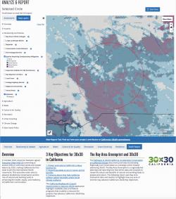
At the same time, GreenInfo began developed visualization concepts for how a tool could work, testing these against the data and analysis work - cycles of review pushed forward a powerful blend of rigorous conservation methods and easy-to-use and compelling web tools. The GreenInfo team worked hard to developed the architecture of the site's functioning,  and our frequent design partner, Ison Design, added graphic design.

GreenInfo GIS staff took on the large task of translating the intensive geospatial data developed by TNC scientists into a format that could function effectively on a website. Simultaneously, GreenInfo web developers translated the evolving site designs into web applications. This work included extensive testing of coding approaches and problem solving to ensure the site could provide the massive data and analysis framework in a way that would work in a browser web browsers.  

A key part of the system architecture is that the majority of the data is contained in a 30-meter "fishnet" grid (about 20 million points), so that web reporting can be achieved mostly with simple arithmetic operations on the points within an area, instead of more intensive (and much slower) sequential querying across dozens or hundred of overlapping polygon datasets. We achieved this speed without loss of accuracy by attaching precise data to each grid centroid without resampling. The data was all processed using Esri desktop GIS software, and prototype cartography was developed for all layers in ArcMap as well. The web application is built in Django on top of a Postgres/PostGIS database and uses Mapserver for cartographic display.

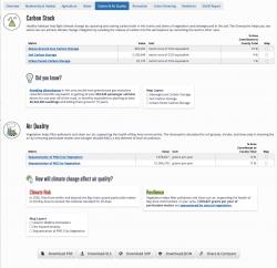
The development of the site also included creating attractive downloadable reports, and lots of effort to adjust the site design to fit needs that emerged as the interaction between all its many elements was refined by the project partners.


Focus:   Conservation  

Services:  Interactive Solutions, GIS Services, Analysis, Data, Applications Development, Web Mapping, Website Design, Mobile Applications 

Tags:   Esri ArcGIS  

Project Years: 2016-2022

GreenInfo Network creates, analyzes, visualizes and communicates information in the public interest. We specialize in mapping and related technology for nonprofits and public agencies, focusing on using it for conservation, social equity, public health, environment and foundation grant making.
2201 Broadway, Suite M5
Oakland
CA
94612
United States of America