New Mapping for Bay Area Ridge Trail

Trail Status (outreach)
The use of solid, dash, and dotted lines signify dedicate, planned, or use gap sections of the trail.
Client:   Bay Area Ridge Trail Council

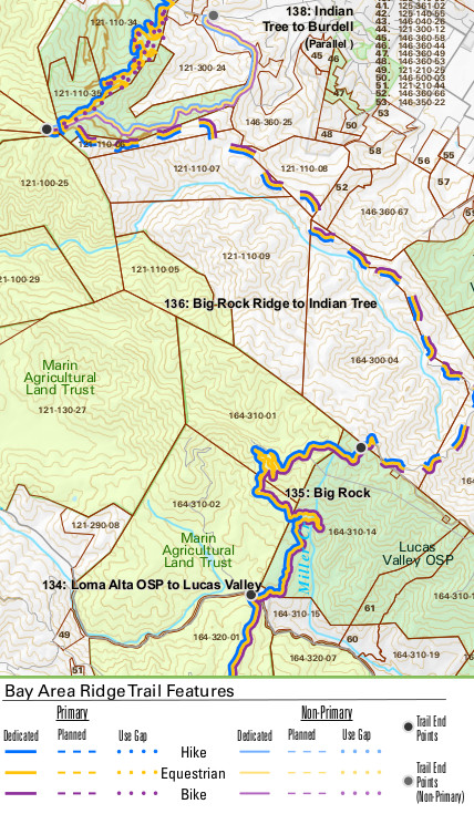
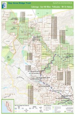
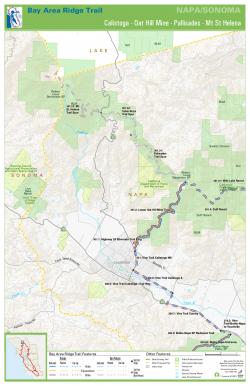
The Bay Area Ridge Trail Council has completed 370 of the 550-mile loop along the ridge line above San Francisco Bay.  For more than 20 years, GreenInfo has supported the Council's efforts with cartographic products and the development and management of a geospatial database. In 2017, we completed new, more detailed maps to reflect the current status of the continuous loop trail.

As Ridge Trail staff work to close the final 180 miles along the 550 mile regional line trail system, they need detailed and up-to-date maps of the trail.  These maps are used intensively in planning, projects, board meetings, landowner and funder outreach, agency engagement, and more. Since the trail status is frequently updated, the GIS mapping needs to be systematic and standardized. Earlier GreenInfo work had provided a more modern map frame design as well as greatly improved cartography for the intricate trail database.

GreenInfo GIS staff created a new series of these maps, particularly for use in general settings such as public meetings or other presentations. This map series highlights nearby parks and open space, campsites, permissible uses on trail sections (hike, bike, equestrian), length, as well as elevation, major roads, and waterways.  To support the Council staff's planning efforts, we developed a second set of the maps that include additional information about parcel lines and ownership.

Both map series show huge amounts of information.  To make them work for users, GreenInfo developed and applied in GIS a highly refined visual hierarchy and symbology, including color, stroke, line width, and labeling to allow users to identify dozens of details while clearly seeing the overall trail route as well.

In addition to the mapping, GreenInfo has also helped improve the overall trail geodatabase that drives the maps, as well as supports the tracking systems for trail progress.


Focus:   Environment, Recreation  

Services:  GIS Services, Data, Maps, Cartography 

Tags:   cartography, Esri ArcGIS, Ridge Trail, San Francisco Bay Area, trails  

“ THANKS so much!! We really appreciate it and are excited about the maps and database.”

—  Janet McBride, Executive Director

Project Years: 2016-2017

GreenInfo Network creates, analyzes, visualizes and communicates information in the public interest. We specialize in mapping and related technology for nonprofits and public agencies, focusing on using it for conservation, social equity, public health, environment and foundation grant making.
2201 Broadway, Suite M5
Oakland
CA
94612
United States of America