See This Project | Similar Projects | All Projects for Client
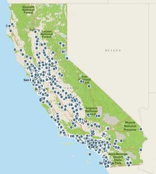
Knowing where playgrounds and other recreational facilities are located is crucial for helping local, state and regional governments figure out where to invest to improve opportunities for physical activity, and to help people find these places easily. GreenInfo came up with an innovative strategy to map over 14,000 facilities.
GreenInfo was tasked to find all the urban recreational facilities in California, to support the Calif. Dept. Parks & Recreation's statewide planning efforts. The recreational facilities we were interested in seeking out were playgrounds, covered picnic areas, tennis courts, basketball courts, community centers, ball fields, skate parks, and swim centers (in cities). While some cities maintain lists of these facilities, formats are inconsistent, data is not geocoded and many cities simply don't have this data.
We developed a MapCollaborator application that enabled a group of seven student interns from Calif. State University, Chico, to work remotely to discover and map these facilities. To help the interns find recreational facilities, we brought in these layers to the application:
- An older recreational facilities layer, created by GreenInfo
- The California Protected Areas Database (CPAD) layer to cue us where there were public parks
- City boundaries
- Schools (to distinguish school sites from parks)
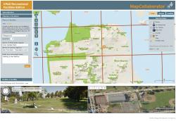
We used these layers in the custom MapCollaborator interface that allowed the interns to visual inspect parks and place points for recreational facilities they found. To track our progress, we laid a grid over the state of California in which each square had a unique ID. These IDs corresponded to a Google Docs Spreadsheet that the interns updated as they inspected the squares. This allowed for completely remote management of the project.
One very helpful function in the MapCollaborator application was to allow users to turn on a combination Google Street View and a Bing Birds Eye (oblique air photo) view of a site, below the main map window (see image). Moving the map also moves these windows, which provide close up views of sites that may not be clear from satellite photos.
The results were impressive. The interns spent a combined 300 hours on the project and found over 14,000 individual recreational facilities. This only includes incorporated places. Although we certainly missed some facilities, we think the data is robust, 95%+ complete and reliable.
Results: California State Parks gained a valuable data to inform statewide recreation planning, and a very detailed database of facilities was made available for broader use.
Focus: Environment, Human Services, Recreation
Services: Interactive Solutions, GIS Services, Data, Applications Development, Web Mapping
Tags: ball fields, courts, Esri ArcGIS, mapcollaborator, playgrounds, recreation
Project Years: 2012