Canopy

A global view
Client:   Canopy

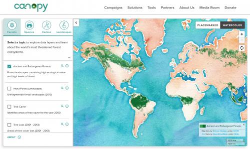
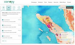
The Canadian nonprofit Canopy approached us to help create an interactive global map of some three dozen data layers critical to their work. Canopy aims to protect the world’s forests, species, and climate by collaborating with business leaders, scientists and decision-makers to help create sustainable supply chains and foster innovative solutions to environmental challenges. Knowing where ancient and endangered forests remain is crucial to their work. They needed a map!

The core challenge of this project was the diversity and scale of data Canopy wanted to include in the map. The map had to work well across both global raster data sets of tree cover to detailed outlines of the ranges of critically endangered tigers and rhinos. 

We rendered a range of data into map tiles using TileMill and then hosted the tiles on Amazon's S3 storage service. Then we built a client-side application that we can configure with data exported from Google Sheets. The completed ForestMapper draws on static content and vector data, plus links to raster tiles on S3, to provide a very speedy and responsive user experience.

In 2020, we updated several key layers on the site.

Focus:   Conservation, Environment  

Services:  Interactive Solutions, GIS Services, Cartography, Applications Development, Web Mapping 

Project Years: 2017, 2018, 2020

GreenInfo Network creates, analyzes, visualizes and communicates information in the public interest. We specialize in mapping and related technology for nonprofits and public agencies, focusing on using it for conservation, social equity, public health, environment and foundation grant making.
2201 Broadway, Suite M5
Oakland
CA
94612
United States of America