See This Project | Similar Projects | All Projects for Client
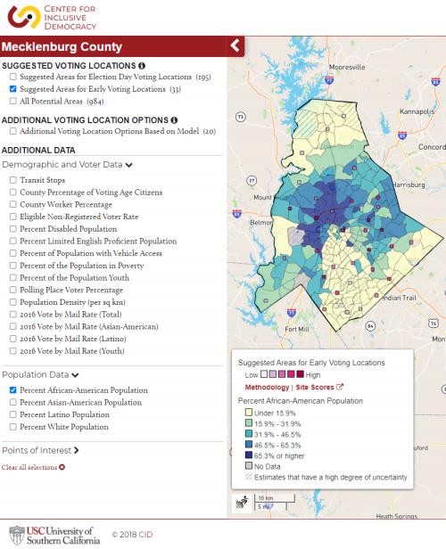
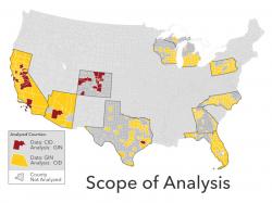
Where counties place vote centers in their community can directly impact turnout for an election. To support registrars in identifying accessible and equitable U.S. voting locations, the Center for Inclusive Democracy (CID) at the University of Southern California (formerly the California Civic Engagement Project CCEP) developed a tool to visualize California Voter’s Choice Act criteria and optimize vote center placement for five California counties. We worked with the CID starting in late 2019 to expand this analysis to cover more states, ultimately analyzing nearly 400 counties across ten states, covering 43% of the U.S. population.
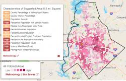
First launched in California during the 2018 Election, the analysis produces a scored grid covering the county's populated areas. It takes many variables, such as vote by mail rates, demographics, and commute information, to produce a score for each grid square.
Based on the number of sites the county registrar provides, it picks the best locations for early voting, ballot drop boxes, and election day voting places.
Results: The success of the Voting Location Siting Tool has been noted by many registrars and voter advocacy groups working toward the accessible and equitable siting and implementation of voting locations.
Focus: Government Agencies, Social Justice/Equity
Services: Interactive Solutions, GIS Services, Analysis, Data, Training and Support, Cartography, Applications Development, Web Mapping, Website Design
Tags: American Community Survey, Census, Leaflet, Python, R
“ The CCEP’s Siting Tool is very helpful to our organization’s voting rights work, and it would be very helpful to have an expanded version of the tool as we work to make the November 2020 election accessible and safe for diverse communities. In our work engaging community leaders on VCA implementation in Napa County and in San Mateo County, we used the vote center siting tool to help community members understand what locations would serve their communities best and to build out our advocacy to county elections offices. The tool is navigable and accessible, and gives us data-informed suggestions that we combine with community knowledge to find ideal locations for vote centers.”
— Julia Marks, Staff Attorney, Voting Rights and Census, Asian Americans Advancing Justice – Asian Law Caucus
“ Sacramento County found the information provided by the CCEP to be consistent and reliable. The tool was actively used in Sacramento County, by election officials and community stakeholders, to identify areas, and actual facilities, that were utilized in both the 2018 and 2020 elections. As counties struggle to accommodate the administration of elections under COVID-19 and experience a limited number of available locations, this tool will become a valuable asset to any election official to ensure actual, historical data is being used for election planning and location siting. I am grateful for the efforts and resources provided by Dr. Romero and the CCEP.””
— Courtney Bailey-Kanelos, Registrar of Voters, Sacramento County
Project Years: 2019, 2020