See This Project | All Projects for Client
When the California Academy of Sciences approached us to help with a pilot project that combines citizen science data with Census data, we knew that this was right up our alley. And that it would be a big challenge!
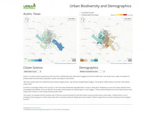
The project was to use data from iNaturalist, a remarkable and fast-growing citizen science application housed at the Academy, alongside Census variables in nine cities that participated in a larger pilot project focused on new ways to monitor and track urban biodiversity.
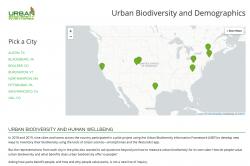
Our first step was to interview as many of the city stakeholders as we could, to understand how they think about biodiversity and equity data in their cities now. The range of cities involved, from Austin and San Fransisco to Blacksburg and Burlington, made it especially challenging to find common threads across the pilot cities that we could also show with readily available data. Some cities have extensive iNaturalist data, some have very little. Some cities stretch across dozens of Census Tracts, others cover only a few.
A core realization in the process of our work is that citizen science data, even when it is an incomplete representation of biodiversity, is itself a social dataset: Who is making observations where in your city? How can those patterns inform future outreach and engagement efforts, to ensure that community based science is as broad and inclusive as possible?
Because each city is so different, we took a hybrid approach to make sure we could deliver a useful product on time and within budget. Each city had the same set of base data from iNaturalist, the Census, and the Trust for Public Land, but then each could also have its own custom layer (for example, trail corridors or specific kinds of public lands). And finally, each city could have its own text narrative, to frame the data with the concerns special to that place.
The long-term goal of this work is to understand how urban biodiversity affects human wellbeing across the breadth of a metro area, and citizen science holds incredible promise in fueling that effort. But a critical early step is understanding how citizen science activity itself does, or does not, spread evenly across the landscape of a city, and how the benefits of that data can be shared as equitably as possible.
Focus: Environment, Social Justice/Equity
Services: Interactive Solutions, GIS Services, Data, Cartography, Web Mapping, Website Design
Project Years: 2019