Similar Projects | All Projects for Client
People of color and those that are in poverty are more likely to live far from California's rich coastal resources. GreenInfo and The City Project have been examining the unequal access of Californians to the coast for over a decade, to help the City Project advocate for maximum public access to the coastal zone while ensuring the fair treatment of all people regardless of culture, color, or income. Recent state legislation now mandates requirements for these policies, driving the need for a new report on the status of coastal access.
In 2016, the California Coastal Act was amended through Assembly Bill 2616 to more explicitly incorporate equal justice requirements promoting access to the coast, along with related provisions. The City Project asked GreenInfo to develop the first-ever mapping of these factors, to help it encourage effective implementation of this new legislation.
The maps/tables and The City Project's overall analysis have been published in a new report, Coastal Justice and the California Coastal Act: An Equity Mapping and Analysis, using updated demographic information. This new the analysis found:
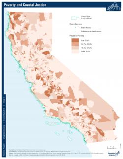
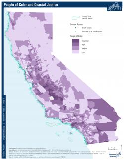
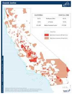
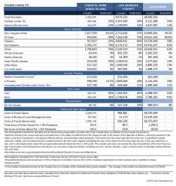
- The coastal zone is wealthier and less diverse than the state as a whole.
- It has median household income nearly $12,000 higher than the state.
- The percent of non-Hispanic whites is 20% higher than in California.
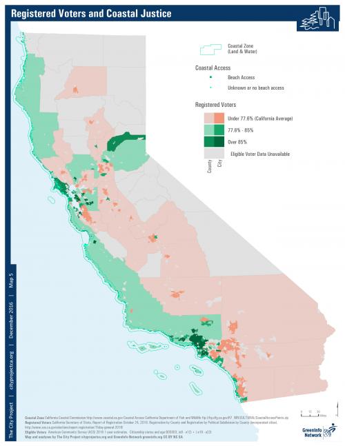
- Registered voters do not reflect the demographics of the state., eligible voters are more likely to register in coastal cities/counties (Amanda - not sure what this means - LO)
Results: The information GreenInfo provided informed the policy brief released with recommendations to the Coastal Commission and staff.
Focus: Environment, Public Health, Social Justice/Equity
Services: GIS Services, Communications, Publications, Analysis, Data, Maps, Cartography
Tags: coast, Esri ArcGIS, Poverty, race and ethnicity, social justice, voter registration
“ This is fascinating. You never cease to amaze me - we could not do what we do without you and your data analysis.”
— Robert Garcia, Founding Director and Counsel
Project Years: 2016