See This Project | Similar Projects | All Projects for Client
The San Francisco Bay Area is the nation's fourth largest metropolitan region, with a population of almost 7 million. But it's also home to an incredibly rich array of biodiversity in the lands upland of the famous San Francisco Bay. GreenInfo was asked to build a web tool that gives anyone the capacity to explore conservation values in the region, as well as provide extensive GIS and mapping support.
The Bay Area Open Space Council's San Francisco Bay Area Upland Habitat Goals Project launched the Conservation Lands Network as a five-year science-based study by over 125 organizations and individuals tasked to identify the most essential lands needed to sustain biological diversity. The study was designed to recommend the types, amounts and distribution of conservation lands as well as actions needed to sustain diverse and healthy communities of plant, fish and wildlife resources in the nine county Bay Area.
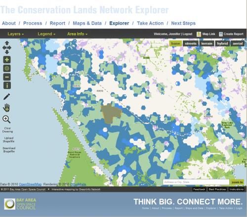
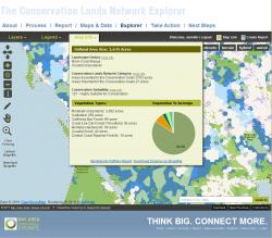
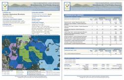
The Council asked GreenInfo to both develop a broad array of maps for the project and to create its capstone web site, featuring a then-unique technique for securing information on local areas of biodiversity. Designed for participants in biodiversity issues and planning, the Conservation Lands Network (CLN) web site features the "CLN Explorer", a map application that enables users to draw custom areas which then select all relevant information in that area and return online charts and summaries and a highly detailed custom PDF report.
Focus: Conservation
Services: Interactive Solutions, Applications Development, Web Mapping, Website Design
Tags: biodiversity, conservation planning, San Francisco Bay Area
“ The Explorer tool is incredible! You have all done a tremendous job and a very important service to the region! ”
— Bettina Ring, Executive Director, Bay Area Open Space Council
Project Years: 2009-2013