California School Campus Database

California Schools Database homepage
Client:   Stanford Prevention Research Center

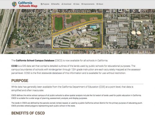
The California School Campus Database (CSCD) is available for download! After nearly five years of development, California now has a robust geographic data set for all public schools.  It's not often we get to develop a new dataset of this size and potential impact. We're looking forward to seeing how it gets used in the world!

CSCD is a GIS data set containing detailed polygons defining the campus boundary of all kindergarten through 12th grade public schools in California.  The boundaries define land used for educational purposes.

Working with Stanford Prevention Research Center, GreenInfo staff have developed the GIS database to allow for detailed analyses of school locations.  CSCD is the first statewide database of detailed schools and provides:
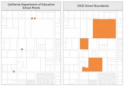
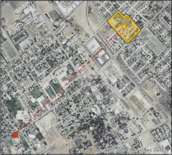
  1. Improved accuracy of school locations
  2. The full extent of the campus
  3. Size of each school campus
  4. Tracking of multi-location school campuses
  5. Attributes reported by the California Department of Education, as well as a unique school identification code (CDS code) to allow data users to join additional attributes.
The nearly 10,300 schools locations are defined using local assessor parcel boundaries, with additional research into land use and zoning data, reviews of the polygons over current aerial imagery, and online research for individual schools.

The data set includes a user manual, key statistics, field descriptions, recommendations, and extensive documentation on methods.

Users are also encourage to provide feedback using GreenInfo Networks MapCollaborator, schools edition

CSCD is available for download and use without restriction.

Results: California now has a comprehensive and accurate GIS data set for all California public schools.

Focus:   Education, Social Justice/Equity  

Services:  Interactive Solutions, GIS Services, Data, Website Design 

Tags:   CSCD, Esri ArcGIS, GIS data, mapcollaborator, school  

“ Many thanks for your incredible work, I’m thrilled to hear about the data release!”

—  Lisa Henriksen, PhD, Senior Research Scientist

“ Wow! Thank you SO much. You have gone above and beyond. ”

—  Nina Schleicher

Project Years: 2012-2016

GreenInfo Network creates, analyzes, visualizes and communicates information in the public interest. We specialize in mapping and related technology for nonprofits and public agencies, focusing on using it for conservation, social equity, public health, environment and foundation grant making.
2201 Broadway, Suite M5
Oakland
CA
94612
United States of America