See This Project | All Projects for Client
Analyzing web maps of large data sets can be very useful - but only if users can take away a digest of this information that is visually accessible. GreenInfo Network has developed approaches to effective report design for PDF files generated from user selections on web maps.
Web maps with many layers give users a wide range of visualization choices. Add to that the ability to define specific areas and extract information for just those areas and you have a highly useful application of this sort of data. But beyond seeing it onscreen, what can users do with it?
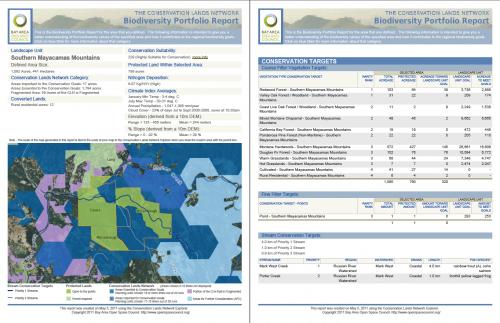
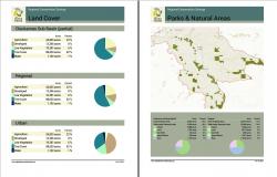
For example, the Bay Area Open Space Council asked GreenInfo Network to develop an effective means for users to get more out of their Conservation Lands Network Explorer application (which GreenInfo created) and our response was to design a carefully formatted document that is generated as a PDF. Users can then take that document, print it, share it or just file it away.
The key is to have careful graphic design of complex information, and then to implement it at the coding level in a proper manner. The coding task for these reports can be a considerable effort, but pays off with highly usable documents. For sites hosted on GreenInfo servers, we typically use WKhtmlToPDF, which reads HTML and can make use of CSS, Open Layers and jQuery. The alternative to this is TCPDF which requires much more effort to implement, often demanding pixel level coding.
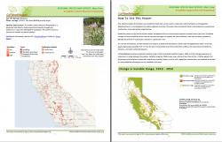
GreenInfo Network has developed these reports for other projects, including the Intertwine Web application in Portland, Oregon, the Cal-IPC Weedmapper application and others.
Focus: Conservation, Environment
Services: Interactive Solutions, Communications, Graphic Design, Publications, Applications Development
Project Years: 2012-current
Documents: BAOSC_CLN_BiodiversityReport_1MGfPtpSCY.pdf, Cal-IPC__SpeciesMap_Russian_knapweed_Report.pdf