Learning about Redistricting with DrawCongress

Draw Congress Map
Client:   Stanford Redistricting Project

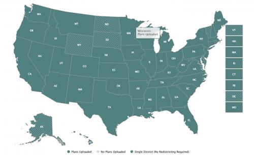
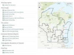
Redistricting, the process of redrawing geographic areas within which eligible residents within that geography vote to elect their representatives, can be equitable or biased (gerrymandering), depending on how it is done. The purpose of redistricting is to ensure voting districts accurately represent population and demographic changes, in order to provide equitable and meaningful representation in Congress and state legislatures. Understanding the process matters, which is why the Stanford Redistricting Project created DrawCongress.org in order to help educate law students and undergraduates on the process, as well as give them the opportunity to participate in redistricting themselves - through data analysis and map-making. We worked with the Stanford Redistricting Project to relaunch DrawCongress.org in 2020, helping to note only update the site, but also provide mechanisms that allowed students to easily interact with and update maps and plans.

For this relaunch, we built a homepage map that shows the status of plans uploaded to the site, as well as which states are redistricting this year. Each page has its own state and lists all plans created for that state, as well as additional resources from other redistricting sites. We created a user-friendly interface so students can easily upload their plans to the site. Each plan can contain many different supporting documents that describe their plan in more detail. A map on the plan page gives a preview of the student’s plan. 

To build this project, we deployed WordPress on an Amazon EC2 server, added the Custom Post Types plugin so each Plan can be it’s own page, and also added the Advanced Custom Fields (ACF) plugin so each Plan can have a structured form for uploading required and optional information about the plans. We use the ACF on-page editing form to allow users to directly edit pages rather than logging into an admin system.

Focus:   Education, Government Agencies, Social Justice/Equity  

Services:  Interactive Solutions, GIS Services, Analysis, Data, Applications Development, Web Mapping 

Project Years: 2021

GreenInfo Network creates, analyzes, visualizes and communicates information in the public interest. We specialize in mapping and related technology for nonprofits and public agencies, focusing on using it for conservation, social equity, public health, environment and foundation grant making.
2201 Broadway, Suite M5
Oakland
CA
94612
United States of America