Similar Projects | All Projects for Client
Since the 2000s, power lines have been planned throughout the U.S., but unfortunately, these routes can have negative impacts on biodiversity and land conservation. The Sierra Club has taken on this issue and needed an effective map to show potential impacts.
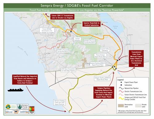
With the threat of the "Sunrise Powerlink" in San Diego County, the local Sierra Club needed to clearly illustrate the existing power corridor from Mexico to Los Angeles. There were existing maps of the current and planned transmission lines, but they were difficult to find and hard to interpret. GreenInfo Network was hired to compile data from various existing maps and create a clear picture of the proposed movement of liquified natural gas in the region.
Focus: Conservation, Environment
Services: GIS Services, Data, Maps
Tags: California, energy, Esri ArcGIS, transmission lines
Project Years: 2009