Evaluating Childcare Enrollment Capacity

Childcare Capacity for Children 0-2
Evaluating the need and capacity for daycare enrollment in Cook County, Illinois
Client:   Policy Analysis for California Education - PACE

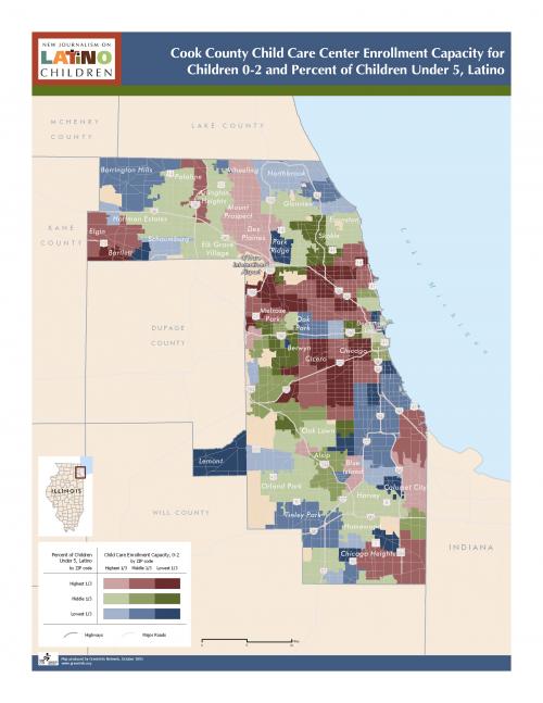
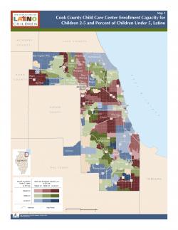
Access to childcare is a complex relationship of enrollment capacity and the location of facilities. PACE asked GreenInfo to develop maps and analysis for various areas of the U.S. to inform their policy research on this topic.

One of the areas mapped was Cook County, Illinois, the Chicago metropolitan region.  To evaluate the location of daycare capacity in relation to different racial and ethnic groups, GreenInfo mapped the density of children (0-2 and 2-5) in each racial/ethnic group.

The series of maps created used a cross-tab summary to highlight:
  • areas of high need and low access (shown in deep red)
  • areas of low need and high access (shown in deep blue)
  • areas of mid level need and access (shown in green)
The maps created clearly define areas where childcare needs and enrollment were in sync.  Additionally, those that where over or under in capacity relative to a racial/ethnic subgroup were identified.


Results:

Focus:   Education, Human Services, Social Justice/Equity  

Services:  GIS Services, Analysis, Data, Maps 

Tags:   daycare, demographics, Esri ArcGIS, schools  

Project Years: 2006 - 2010

GreenInfo Network creates, analyzes, visualizes and communicates information in the public interest. We specialize in mapping and related technology for nonprofits and public agencies, focusing on using it for conservation, social equity, public health, environment and foundation grant making.
2201 Broadway, Suite M5
Oakland
CA
94612
United States of America