See This Project | Similar Projects | All Projects for Client
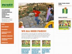
Most communities in Los Angeles are park poor. With a goal of improving access to parks and recreation, Los Angeles County set out to study the most pressing park and recreation facility needs. The study focused on understanding where parks are needed, how to improve accessibility, what facilities are needed, and maintenance - and it used GreenInfo's CPAD data and related tools.
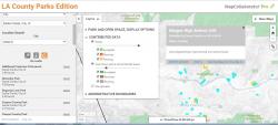
In partnership with Placeworks, which was the lead consultant to the County, GreenInfo led the efforts to update and improve over 3,000 park records. The updates were done through an online portal developed by GreenInfo and allowing approved users to enter comments, park areas, as well as submit existing geo-spatial files. This web portal accommodated the input of comments from over 100 agencies which was organized and coordinated by Placeworks staff. The feedback was synthesized and integrated into CPAD2015b. Over 700 new park units were added, many older park boundaries were snapped to parcels, and core attributes were improved. The existing structure and years of data in CPAD allowed for the entry of over 15,000 new acres by over 150 contributors in less than 6 months.
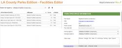
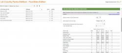
Alongside the park improvements, recreation facility information was collected for approximately 2,000 parks. A custom addition of the Facility Portal to our innovative MapCollaborator Pro tool was built to enable the entry of the number, and quality, of facilities at any park. The focus of this customization was to build a user friendly system accommodating the census of 20 facility types desired by the County. Navigation, search, query, and screen layout were all developed for ease of use. Databases relationships and linkages were developed to allow the entry of new and revised park information, entry of facilities specific to parks, photos, and notes. The resulting "park and recreation needs" MapCollaborator appears to be a first-of-its kind and made possible huge levels of active engagement with almost a hundred agencies. All told, 100 agency representatives used the online portal to contribute feedback. More than 3,000 parks were updated in CPAD, facility information was collected for 2,000 of of the parks in the county, and potential park sites were identified.
Los Angeles County has posted the information used in this assessment at its Park Needs Assessment website.
Results: In November 2016, voters in the county overwhelmingly passed Measure A, a $1.9 billion parcel tax measure which will support improving and adding parks over the next two decades, generating almost $96 million per year - the largest local park bond in the history of the U.S. GreenInfo is proud to have played a role in this amazing effort, proving that our focus on a comprehensive and accurately inventory of parks (CPAD) is a dynamic tool for improving people's lives.
Focus: Conservation, Environment, Public Health, Recreation
Services: Interactive Solutions, GIS Services, Communications, Strategy, Analysis, Data, Maps, Web Mapping
Tags: CPAD, Esri ArcGIS, Los Angeles, open space, park equity, parks, playgrounds, recreation, schools
“ Thanks for making this difficult project it look so easy. Really and truly, great work! Thanks again for your effort on this project. ”
— C.C. LaGrange, Landscape Architect
“ I also just wanted to give you guys kudos for putting this together. The web portal is very user friendly. We are excited to see the finished product.”
— Gustavo Hernandez, Recreation Supervisor, City of Huntington Park
“ Good stuff! I want to thank you again for all of you hard work on this and rolling with the punches along the way. It was a monstrous effort and it appears that all the bits and pieces have been successfully wrangled and corralled. Great work! ”
— Rob Mazur, GIS Assistant Manager
Project Years: 2015