Similar Projects | All Projects for Client
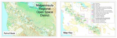
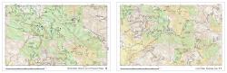
Rangers for regional open space districts need to manage large areas of open parkland, checking on gates, responding to security calls, tracking hikers and more. The Midpeninsula Regional Open Space District asked GreenInfo to build a GIS atlas that could be printed and carried by rangers on their patrols, which are often far away from Internet connectivity.
The patrol atlas created by GreenInfo was an oversize 11"x17" bound document, with maps on facing pages. Each map was generated using and automated system in our Esri ArcGIS software. Page elements were defined using contours and detailed trail and point locations for a large variety of features.
Focus: Environment
Services: GIS Services, Maps
Tags: Esri ArcGIS
Project Years: 1999