Similar Projects | All Projects for Client
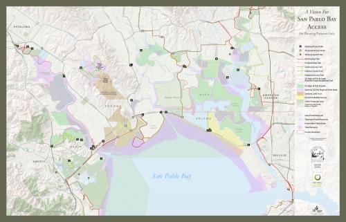
Just north of San Francisco, the San Pablo Bay wetlands region is a complex array of land ownerships and protection status. The San Francisco Bay Joint Venture organization asked GreenInfo to clarify those boundary issues and develop a map to be used in guiding tours of the area.
JOHN - add description
A zoomable version of the map is available through: http://www.mapsportal.org/demo/deep-zoom/
Also used in Bay Nature?? relate to Louis map?
Focus: Conservation
Services: GIS Services, Data, Maps
Tags: California, Esri ArcGIS, trails, Wetlands
Project Years: 2010