See This Project | Similar Projects | All Projects for Client
The Intertwine Alliance's Regional Conservation Strategy (RCS) covers 1.8 million acres, ten counties, and two major metropolitan areas. Developed through extensive GIS analysis and public engagement, the Alliance's strategy needed a robust web mapping platform to allow broad access to the RCS findings, and GreenInfo was asked to develop it.
In 2013 the Intertwine Alliance, with generous funding from the Bullitt Foundation and project management by Columbia Land Trust and Portland Metro, contracted with GreenInfo Network to build the Regional Conservation Strategy (RCS) Viewer.
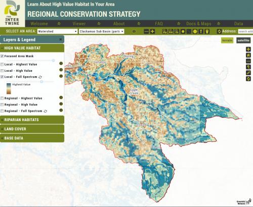
The Regional Conservation Strategy is a vision and a plan to identify and protect habitat and natural areas in the area surrounding Portland, Oregon and Vancouver, Washington. One component of the RCS is a set of data grids modeling habitat value and land use, and these are used in traditional desktop GIS to estimate the impact of a proposed project. The RCS Viewer allows this "area query" to be performed in the browser without specialized GIS knowledge, simply by selecting an area from the list, by drawing it, or by uploading a shape file. With this information readily available, interested parties such as city planners can determine the impact of a project upon valuable habitat and land cover, and make more informed decisions.
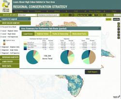
In moments, a detailed mini-report shows statistics and pie charts of land cover, habitat valuation, and protected areas within the selected area, and a link is provided to generate a take-away PDF report. This browser interface greatly reduces the time and overhead of using the RCS model, providing valuable information to interested parties on the acreage of habitat which may be impacted by a given project.
GreenInfo's work on this Explorer project included extensive data processing in GIS, as well as a major web application-building effort. Of technical interest, are the back-end data processing and the PDF generation. The selected polygon area (upload, selection, or drawing) is analyzed via PostGIS's raster capability, evaluating pixel values and generating the statistical content. PDF reports are generated using the WKhtml suite of tools, allowing us to design attractive PDFs in HTML and CSS much more quickly than with traditional PDF techniques.
Results: The RCS Viewer was met with enthusiasm at the 2013 Intertwine Summit, as its functionality coincides almost perfectly with the typical use case of the RCS data: selecting an area of interest, then receiving back reports of habitat valuation and land cover. This would normally be done in desktop GIS by the local GIS department, but can now be done in minutes without specific GIS knowledge.
Focus: Conservation, Environment
Services: Interactive Solutions, GIS Services, Data, Applications Development, Web Mapping, Website Design
Tags: biodiversity, habitat, modeling, Oregon, Portland, riparian, urban development, urban planning
Project Years: 2013
Documents: ColumbiaLT_Intertwine_RCS-PDF_Clackamas_River_Subbasin.pdf