Similar Projects | All Projects for Client
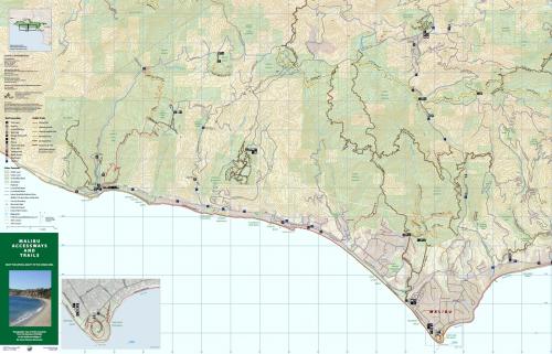
The City of Malibu sits in the middle of a tremendous recreation resource, the Santa Monica Mountains (as well as its Pacific Ocean beaches). GreenInfo was asked to develop a trails map for the city's "backyard", to help any hiker or other visitor to better access the area for recreation.
GreenInfo started the project using GIS software to quickly "mock up" the map concept for the City to review - an advantage of using GIS! Once extent and content were defined, we developed a layout for the eventual publication, allowing for it to be folded when printed.
From there we refined trail, other feature data and labels, reviewing it with many people to ensure accuracy. The finished map uses contours over shaded relief, with careful attention to the hierarchy of labels and fonts, and includes a GPS grid as well. The entire GIS-based product was then exported into Adobe Illustrator for print production.
Focus: Environment, Government Agencies
Services: GIS Services, Communications, Publications, Maps
Tags: Esri ArcGIS, Malibu, Santa Monica Mountains, trails
Project Years: 2011-2012