See This Project | Similar Projects | All Projects for Client
Ensuring access to parks for everyone in urban areas is a big challenge, requiring a long term commitment and a mix of careful analysis and effective advocacy. GreenInfo has provided mapping and data side of this mix to The City Project for over a decade, helping them create parks in underserved areas (particularly for children), push for policies to improve health, and generally advance the cause of social equity in Southern California and beyond.
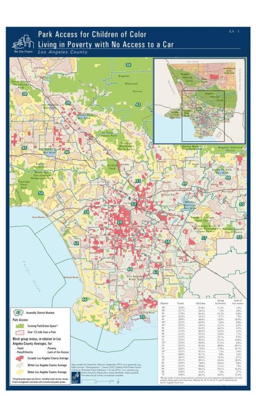
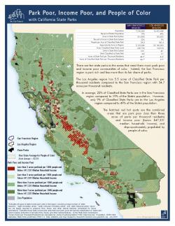
The City Project (TCP) has made access to parks for communities of color and those living in poverty a central issue in its organizational mission. Early on, TCP engaged GreenInfo to be its partner in developing detailed analyses of these issues and creating maps and reports to educate policy makers, the media and the public about their findings.
Individual projects that GreenInfo has completed with The City Project are described in more detail in other project entries, but an overview of our work with TCP exists at their Mapping Green Access web page.
Examples of how this work is communicated are found in these online posts in the TCP series "Green Justice", regarding parks issues in Los Angeles:
Full and Fair Funding for Parks and Recreation, and a Healthier, Prosperous City
Race and Place Do Matter: Economic Hardship, Obesity and Equal Justice
A complete gallery of related maps and documents is at the TCP Flicker site.
Focus: Environment, Social Justice/Equity
Services: GIS Services, Analysis, Data, Maps, Cartography
Tags: California, equity, Esri ArcGIS, parks, social justice
“ The City Project could not do the work we do to create places and policies for students to move more, eat well, stay healthy, and do their best in school and in life without relying on the information we receive from GreenInfo Network's in terms of GIS mapping and demographic data. We have worked with them for ten years and look forward to ten more.”
— Robert Garcia, Founding Director and Counsel, The City Project
Project Years: 2008-2013, ongoing