See This Project | Similar Projects | All Projects for Client
Investing five years and $150 million in protecting wilderness in California requires a multi-faceted approach. To help it support such a program, the Resources Legacy Fund invited GreenInfo to provide mapping and information support to it and scores of grantees.
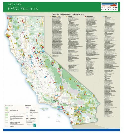
In 2005, the Resources Legacy Fund (RLF) launched a five-year, $150 million program designed to preserve California's wild lands and rivers, and to ensure their permanent protection by investing in systematic acquisitions of land and fostering supportive policies, organizations, and constituencies. Called Preserving Wild California (PWC), the program offered grants and loans wildlands acquisition, planning, policy and advocacy, constituency building, nonprofit organizational capacity building, and stewardship and restoration.
In addition to supporting planning efforts for the program, GreenInfo's role during the five year period was three-fold:
- Assist grantees with GIS projects and technical support, helping land trusts, wilderness advocates and others with mapping, data and spatial analysis.
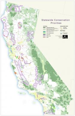
- Support RLF's grant making activities, including defining initial conservation priorities, tracking specific acquisitions, helping shape grant databases, developing tracking maps and graphics, and preparing presentations PWC objectives and progress.
- Conduct independent research and data development, including significant work on building the California Protected Areas Database (CPAD).
During the program GreenInfo worked with over 50 land trusts and other conservation organizations, and produced hundreds of maps and graphics for use by RLF in grant deliberations and tracking.
Results: Among other important outcomes, PWC funding protected almost 200,000 acres of land directly, contributed measurably to the Wilderness designation of more than one million acres of California wildlands, and boosted the capacity of over 100 grantees. GreenInfo mapping supported all of these accomplishments, along with others.
Focus: Conservation, Philanthropy
Services: GIS Services, Data, Maps, Cartography
Tags: California, Esri ArcGIS, PWC, RLF, Wilderness
Project Years: 2004-2010