Similar Projects | All Projects for Client
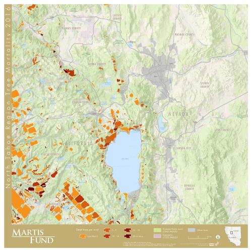
Drought has severely damaged California's forests in the Sierra Nevada. Unseasonably warm temperatures and lack of moisture have fostered the spread of bark beetles and brought other stresses, killing over 100 million trees in the mountain range and more throughout the state. The Martis Fund is a philanthropy that supports forest management and habitat restoration in the North Lake Tahoe region and asked GreenInfo to prepare maps showing the nature of tree mortality in their region.
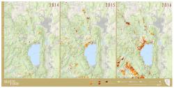
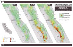
GreenInfo used the USFS data to prepare more focused maps for the region of concern to The Martis Fund. These maps use branding developed earlier for the fund, and include both a year by year comparison map, as well as a single map for the immediate region where The Martis Fund operates.
The most recent year data, for 2016, shows several distinct patterns from the aerial survey that may be subject to further revision as the data is processed. The data breaks used by GreenInfo are not yet calibrated to the degree of threat (for instance, it is undetermined whether 5-9 trees per acre is a significant loss rate or a closer-to-normal rate). These will be further assessed in the future. Regardless, the rapid advancement of tree mortality is unmistakable and of great concern to anyone who cares about the Sierra.
The maps were developed using Esri ArcGIS software, and printed as large posters for use by the fund.
Focus: Conservation, Philanthropy
Services: GIS Services, Maps
Tags: Esri ArcGIS, forests, national forests
Project Years: 2016