When the Transportation Agency of Monterey County undertook their Regional Conservation Investment Strategy (RCIS), they wanted to do more than make a giant document that would sit on a shelf. According to California Department of Fish and Wildlife, "An RCIS is a voluntary, non-regulatory, and non-binding conservation assessment that includes information and analyses relating to the conservation of focal species, their associated habitats, and the conservation status of the RCIS land base." Only a handful of RCIS documents have been developed, and even fewer have been approved. The key challenge was how to take the content of a 700-page and make an interface that would help people on the ground in Monterey to find the elements of the report that are relevant to them.
AECOM, the prime contractor developing the RCIS, had seen our work on
the Bay Area Greenprint
and contacted us to see if we could build a website and search system
for the 54 goals, 80 objectives, and 256 actions across 34 species and
other conservation targets prioritized in the investment strategy as
approved by CDFW. The main task that the final application assists with is to search by
species or by location to determine, for a given project in a given
place, which actions would help support the regional conservation
investment strategy.
We started with user research, conducting interviews with several key users to help us understand their roles in local development and conservation projects and where our system would fit into their existing workflows. Then we did an inventory of the content of the final document as well as the spatial data that AECOM had assembled in creating habitat maps and other supporting attributes of the overall strategy.
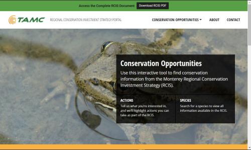
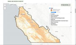
We designed the site with an approachable landing page, a framework of guidance, and a search system to navigate by species or by location. For location search, we coded the modeled habitat for all 34 target species into a 30-meter fishnet grid for efficient filtering to show in any user-selected area which species from the RCIS have habitat in the user's area of interest.
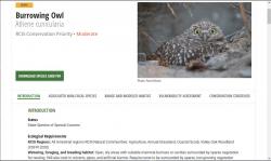
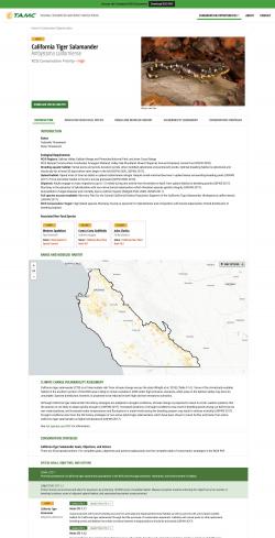
Each species or conservation target has its own dedicated page, with detailed maps and multiple contextual layers, and a list of all relevant goals, objectives, and actions, as well as a quick download of the PDF for the relevant section of the full CDFW-approved document.
Focus: Conservation,
Environment
Services: Interactive Solutions, GIS Services, Analysis, Data, Applications Development, Web Mapping, Website Design
Project Years: 2019, 2020