Raising Regenerative Farming and Ranching Awareness

Client:   National Center for Appropriate Technology

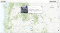
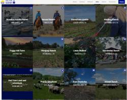
The National Center for Appropriate Technology (NCAT, ncat.org) is a 501(c)(3) non-profit organization with programs in sustainable agriculture and sustainable energy. As part of their Soil for Water Project (soilforwater.org), they wanted to work with GreenInfo Network to create a user-generated map-based content management system featuring profiles of innovative farmers and ranchers who have improved soil health and rainwater capture on their farms. The goal of this map-based content management system is to raise awareness of regenerative farming and ranching, encouraging readers to join a peer-to-peer network of landowners and land managers.

The system has a Django backend, where admins have a login to manage the listing of all farms and ranches. There is a public-facing signup form with profile photo crop and upload tool as well. Bootstrap and jQuery were used for frontend work to build a responsive iFrame and photo grid of farmers. We also built an iFrame resizer on the parent page. 

We used Mapserver for the tile layers and spatial queries. In practice, when a farm is submitted via the application, it does a spatial intersection to add location specific attributes to the farm, like watershed (HUC4), Eco Region, and Plant Hardiness Zone attributes. We also used Leaflet to provide custom filters and controls in the map.

Focus:   Conservation, Education  

Services:  Interactive Solutions, Applications Development, Web Mapping, Website Design 

GreenInfo Network creates, analyzes, visualizes and communicates information in the public interest. We specialize in mapping and related technology for nonprofits and public agencies, focusing on using it for conservation, social equity, public health, environment and foundation grant making.
2201 Broadway, Suite M5
Oakland
CA
94612
United States of America