See This Project | Similar Projects | All Projects for Client
Resources Legacy Fund, a longtime GreenInfo client and supporter, approached us with an important new project: Creating maps for the Open Rivers Fund, launched in 2016. Over the next decade, that fund, created with leadership and support from the William and Flora Hewlett Foundation, and in celebration of Hewlett’s 50th anniversary, will support local community efforts to remove obsolete dams, modernize infrastructure, and restore rivers across the western United States. The Fund aims to create significant economic, community, and environmental benefits by undertaking projects with widespread community support and collaboration.
Our maps serve two purposes for the program: One set of maps portrays the individual watersheds where the fund is focusing. But we also needed to convey the overall scope of the work and the massive potential in the rivers of the Western United States.
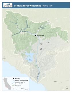
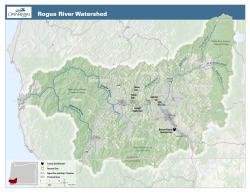
Project maps are simple, clean, elegant. They tell the story of a watershed and the dam or dams in that watershed. Careful use of topography and inclusion of protected lands helps give more real world context to each map. General maps of all projects are used by RLF on their web site, as well.
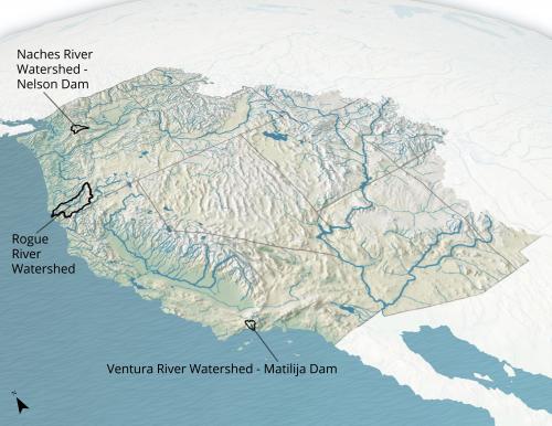
The map showing the overall coverage area of the fund was much more challenging. We started with spare two-dimensional maps highlighting rivers across the United States. These worked well enough as information, but they weren't do the communications work we needed them to do, giving a sense of huge potential while also foregrounding the first three watersheds where the fund is focusing.
So we took a turn to 3D. Using ArcPro, we tilted and rotated our view. With a bit of foreshortening, the project areas stand out. But scaling back the Eastern U.S., Mexico, and Canada, the map clearly focuses on the overall Fund coverage of the Western U.S. Finally, we took the map out of Arc and into GIMP (the open source photoshop alternative) and applied a wave pattern to the ocean, along with a few other visual effects, to give the whole map the feel of an illustration.
Focus: Conservation, Environment
Services: GIS Services, Communications, Graphic Design, Maps, Cartography
Tags: Esri ArcGIS, rivers
Project Years: 2016 onward