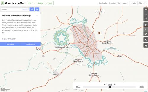
For many years, a group of historians and history enthusiasts had a vision: Take the tools that OpenStreetMap uses to make a volunteer map of the world as it is, and use those tools to make a map of the world as it was. Everywhere, at any time. That's a tall order, but it's now possible to imagine OpenHistoricalMap (OHM) slowly building over time into a growing and truly open historical map of the world.
GreenInfo Network got involved in the project when one of the OHM leads, Jeff Meyer, came to a MapTime meetup at our Oakland office in 2017. OHM's small corps of volunteers had taken the project far, but they needed to substantially overhaul their technology stack and cartographic approach to achieve a key goal: A timeslider that animates the map through time.
The vision for the project is what brought us in: Opening the way for communities to map their own histories, for historians and students to create and share data to allow important stories to be told, and shared.
But this project was also highly technical, and we knew this project would take more OpenStreetMap depth than we have on our staff, so we've engaged with a series of partners, including Seth Fitzsimmons (now at Amazon), Jim McAndrew (with the National Park Service), and more recently Sanjay Bhangar and Sajjad Anwar from DevelopmentSeed, the company out of which Mapbox formed.
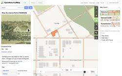
Working with these partners, we have developed a set of vector map tiles with dates baked in, a timeslider to filter those tiles by year, backend data systems that can handle very old dates (like -10,000), updates and evolving map styles to capture a wide range of historical features, and a new side panel "Inspector" to showcase historical images, data from Wikipedia, and other metadata. All of our changes are made in
open source repositories, many forked from the OpenStreetMap organization, with active user discussions on the OSM Slack And Discord groups.
This project will continue to evolve and change over time, and we're excited about the possibilities!