See This Project | Similar Projects | All Projects for Client
San Diego County in southern California has one of the most complex patterns of parks and other protected areas in the entire United States, providing the over three million residents and millions more visitors with outstanding recreational opportunities and vital natural habitats. GreenInfo has worked for many years with The San Diego Foundation, and they asked us to develop a park finder to highlight all of these natural resources.
Because of GreenInfo's long history creating and managing the California Protected Areas Database (CPAD), as well as our prior work with the foundation, we had a solid base of data to start from, including related work we had done on the CaliParks.org statewide park finder. Our strategy had several elements:
- Connect with and engage key groups and agencies in San Diego County to sort out needs and opportunities
- Prepare the actual data through intensive review
- Design and then build a web application
- Promote the application and develop longer term support for its ongoing use
CONTACTS: We reviewed information for and undertook discussions with more than a dozen groups and agencies in the county, along with many blogging and related outdoor recreation resources. We found that many of them had reasonable approaches for their own uses, but there was little interconnection, and overall, the quality of map-related resources was not high. We came away appreciating the tremendous diversity of groups working on outdoor recreation-related missions and projects in the county—a tribute to high quality of local leadership there.
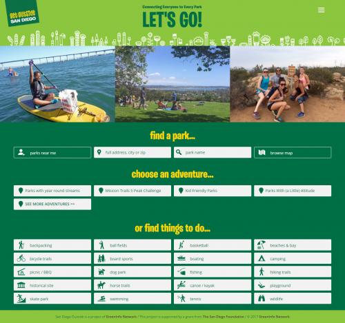
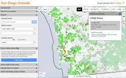
DATA: While CPAD was mostly complete for San Diego, we found that it needed many improvements. We used GreenInfo's MapCollaborator system for much of this, carefully reviewing many individual parks for access and boundaries, and for defining main park entry points (see all the green notes on the image at left). We also developed primary entry points for parks over 10 acres, to improve the Google-based directions we offer on the web application at GetOutsideSanDiego.org. Finally, we improved our CaliParks.org recreational activities assignments, tagging every park with up to 20 attributes (fishing, hiking, biking, etc.). We carefully reviewed each park agency's data to do each of these steps. All told, there are 1,100 parks and open spaces in the county, and all of them are in our data.
APPLICATION: The web application had several elements of its own:
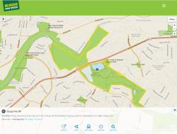
- Base map: using the new Mapbox-based ParkInfo web cartography developed by GreenInfo staff, we added various details to this based map for just San Diego, including showing peaks over 500', playground sites, trails (from OpenStreetMap), and park entry points.
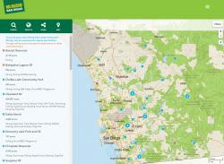
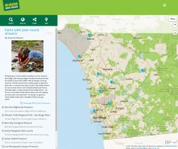
- Design of approach: one of the biggest challenges was defining the specific functions and layout of the web application. We knew that we wanted people to be able to find parks by name, and by type of recreation available, but what more could we offer? In response, we developed (out of many options!) the concept of curated Adventures — custom lists of places/parks with descriptions you can be view each on a dedicated map page. The Adventures function is available to select users who then get access to a special editing panel where they can locate and add notes on their list. See one of these in action here.
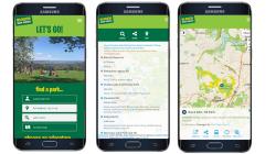
- Programming of the application: GreenInfo uses open source programming tools for its web applications. For building GetOutsideSanDiego.org, we blended the best of newer and more long-standing web technologies, with a front-end application built with React, a Leaflet map serving our custom Mapbox basemap, and a PHP-based administrative interface for authoring Adventures.
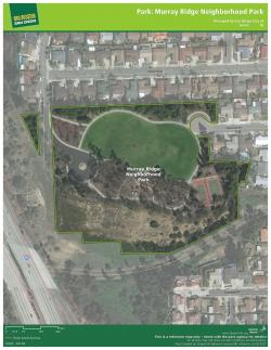
- Park maps for application: To help users do more than find parks on a computer or phone, we developed a system to generate page size PDF maps of 400 parks that were larger than 10 acres. The maps, created using Esri ArcGIS map book technology, show park boundaries over high resolution air photos and can be used to print for actual visits, or for flyers or presentations.
- Building the rest of the web site: In addition to the park finder application, GetOutsideSanDiego.org has many other resources — lists of the many nonprofits working on parks in San Diego County, a Twitter list that gathers together major local outdoor voices, a detailed list of other recreation resource links, and more.
Focus: Environment, Philanthropy, Recreation, Social Justice/Equity
Services: Interactive Solutions, GIS Services, Data, Maps, Applications Development, Web Mapping, Website Design, Mobile Applications
Tags: California, Esri ArcGIS, parks, recreation
Project Years: 2015-2017