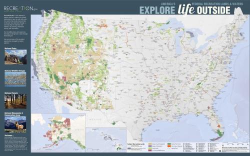
Federal agencies manage huge swaths of land and water for recreational purposes. These agencies range from the National Park Service to NOAA, which manages marine protected areas, and they coordinate with each other through the Federal Recreation Council. And, reservations at federal (and some other) recreation sites are managed by Recreation.gov, which also coordinates with all these agencies. Because of GreenInfo's work on the Protected Areas Database of the U.S. (PAD-US), we were asked by the National Park Service to create a modern version of a 1970s poster showing the recreational lands and waters of the U.S. - and do it by collaborating with all these various partner agencies, including Recreation.gov, the national park reservations service.
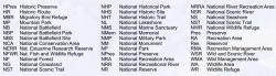
There are seven primary federal agencies that manage land and water areas that are open to public recreation:
National Park Service,
Forest Service,
U.S. Fish and Wildlife Service,
Bureau of Land Management,
Army Corps of Engineers,
Bureau of Reclamation, and the
National Oceanic and Atmospheric Administration. Together, these agencies are responsible for recreation on millions of acres, lands and waters used by millions of Americans and foreign visitors.
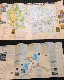
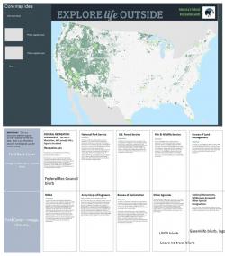
In the 1980s, these agencies had commissioned a poster showing these lands on a map and describing the agencies and opportunities on the back side (see images at left). Lots has changed since then and many felt it was time to create a new poster, for use in tourism outreach and other promotional and educational work.
Developing a showcase poster that highlights the incredible array of federally-managed natural treasures required two parallel efforts - working with the individual agencies to define how they wanted to portray themselves, and working with the data on each agency to know how to place that identity on a map.
The agency coordination was made easier due to the
Federal Lands Working Group, an interagency body managed by the
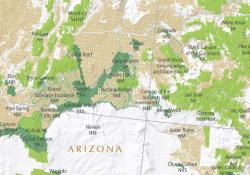
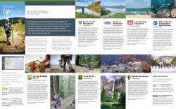
USGS team that publishes PAD-US, the official national inventory of protected areas. Over the past several years, this group has been the go-to meeting point for those in agencies who manage the GIS data on federal lands. GreenInfo, through its work on PAD-US, has been part of the Group and was able to coordinate the subset of agencies relevant for this mapping project. The key challenge was that on a 32" x 20" poster map, there are only so many places that can be labeled, meaning agencies had to prioritize from a much larger set of data down to about 500 that could be actually labeled - this involves tricky balancing, to make sure key sites are noted, even if they are not large! Agencies also had to define themselves in a set amount of text for the back side of the poster and provide key images that would all balance together.
In addition, in September, after an initial draft in June, we revised the map to feature the new branding of
Recreation.gov, the nationwide reservations system, which launched a greatly improved website and branding in October 2018.
The map side of the project was made much easier by having PAD-US (we used a working version of the forthcoming "2.0" PAD-US), but we still had to do extensive querying to define the types of land each agency needed to show, define the colors to be used to show them on the map, and overlay national monuments and recreation areas - all done by going back and forth to the agencies to make sure these selections were accurate. We then had to add selected
National Scenic Trails managed by the Park Service - and then we moved to the labeling.
Providing consistent names for 500 locations and placing them so that they don't overlap is a huge GIS task. We used the PAD-US data and then adjusted it for naming consistency (we had to use abbreviations for "National Forests" = "NF", etc.). We converted these labels to annotation in Esri ArcMap, but we still had to hand place ever label to ensure readability and working with nationwide data means it can take seconds for a single label redraw when moved.
The overall map side design emerged out of efforts by several GreenInfo staff to come up with creative approaches for such a map, including the map title/tagline, "Explore Life Outside - America's Federal Recreation Lands & Waters".
The backside of the poster was designed roughly to determine how much text we could allot to each agency and other elements we needed to make room for. We also worked with agencies to find appropriate images for each, that fit with the directions of intended use. Final graphic layout and preparation of print files was done by our frequent partner,
Ison Design.